Home > Arts > Artists > J > Thomas Jefferys
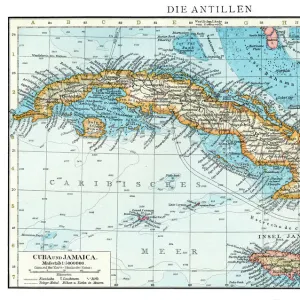
Geography Atlas: representation of the island of Hispaniola (Haiti and Santo Domingo) and the passage of the Winds (or Under-wind) in the Caribbean archipelago. Below is a Wind Rose
 and the passage of the Winds (or Under-wind) in the Caribbean archipelago. Below is a Wind Rose")
![]()
Wall Art and Photo Gifts from Fine Art Finder
Geography Atlas: representation of the island of Hispaniola (Haiti and Santo Domingo) and the passage of the Winds (or Under-wind) in the Caribbean archipelago. Below is a Wind Rose
VEN5030000 Geography Atlas: representation of the island of Hispaniola (Haiti and Santo Domingo) and the passage of the Winds (or Under-wind) in the Caribbean archipelago. Below is a Wind Rose. Map taken from "The west indian atlas or general description of west indies"" by Thomas Jefferys, geographer of the Prince of Wales, 1774. Biblioteca Jose Marti, Havana, Cuba.; (add.info.: Geography Atlas: representation of the island of Hispaniola (Haiti and Santo Domingo) and the passage of the Winds (or Under-wind) in the Caribbean archipelago. Below is a Wind Rose. Map taken from "The west indian atlas or general description of west indies"" by Thomas Jefferys, geographer of the Prince of Wales, 1774. Biblioteca Jose Marti, Havana, Cuba.); © Marage Photos
Media ID 38165914
© © Marage Photos / Bridgeman Images
18eme Siecle Amerique (continent) Amerique Centrale Amerique Du Nord Caraïbes Caribbean Caribbean Island Carte Geographique Central America Dominium Etats Unis Geographical Map Geographie Haiti Saint Domingue Stockravenna
FEATURES IN THESE COLLECTIONS
> Arts
> Artists
> J
> Thomas Jefferys
> Arts
> Artists
> N
> Thomas North
> Europe
> United Kingdom
> Wales
> Maps
> Europe
> United Kingdom
> Wales
> Related Images
> Fine Art Finder
> Artists
> Charles Robert Knight
> Maps and Charts
> Early Maps
> Maps and Charts
> Wales
> North America
> Cuba
> Cuba Heritage Sites
> Old Havana and its Fortification System
> North America
> Cuba
> Havana
> North America
> Cuba
> Maps
EDITORS COMMENTS
This stunning print captures a detailed representation of the island of Hispaniola (comprising Haiti and Santo Domingo) and the passage of the Winds in the Caribbean archipelago. The map, taken from "The West Indian Atlas or General Description of West Indies" by Thomas Jefferys in 1774, showcases intricate geographical details with a Wind Rose below.
Dating back to the 18th century, this engraving offers a glimpse into early cartography and exploration of Central America and the Western Hemisphere. The map provides valuable insights into navigation routes, wind patterns, and dominium territories during that era.
The historical significance of this Geography Atlas is further emphasized by its presence in Biblioteca Jose Marti in Havana, Cuba. It serves as a reminder of the rich cultural heritage and maritime history associated with the Caribbean region.
As we admire this piece of artistry, we are transported back in time to an age when maps were not just tools for navigation but also symbols of power and discovery. The meticulous craftsmanship evident in every detail reflects the dedication and expertise of geographers like Thomas Jefferys who played a crucial role in shaping our understanding of geography.
This print is not just a visual treat but also a window into our past, reminding us of the interconnectedness between land, sea, and human civilization throughout history.
MADE IN THE UK
Safe Shipping with 30 Day Money Back Guarantee
FREE PERSONALISATION*
We are proud to offer a range of customisation features including Personalised Captions, Color Filters and Picture Zoom Tools
SECURE PAYMENTS
We happily accept a wide range of payment options so you can pay for the things you need in the way that is most convenient for you
* Options may vary by product and licensing agreement. Zoomed Pictures can be adjusted in the Basket.