Home > Animals > Mammals > Spalacidae > Antiquus
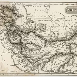
Maps of the ancient Persian and Macedonian empires (coloured engraving)
")
![]()
Wall Art and Photo Gifts from Fine Art Finder
Maps of the ancient Persian and Macedonian empires (coloured engraving)
7148246 Maps of the ancient Persian and Macedonian empires (coloured engraving) by Kiepert, Heinrich (1818-99); Private Collection; (add.info.: Maps of the ancient Persian and Macedonian empires. Illustration from Atlas Antiquus, Twelve Maps of the Ancient World for Schools and Colleges, by Dr Henry Kiepert (Dietrich Reimer, Berlin, c1889).); © Look and Learn
Media ID 25142006
© Look and Learn / Bridgeman Images
2nd Century Bc 3rd Century Bc 4th Century Bc Atlas Cartography City Map City Plan Conquests General Map Iiird Century Bc Iind Century Bc Iran Iranian Iranians Ivth Century Bc Macedonia Macedonian Macedonians Persia Persian Persians Street Plan Vistory Greece Greek Greeks Mythological Character Mythological Figure Myths Pagan Paganism Pagans Polytheism Polytheist
FEATURES IN THESE COLLECTIONS
> Animals
> Mammals
> Spalacidae
> Antiquus
> Arts
> Artists
> M
> Macedonian School Macedonian School
> Asia
> Iran
> Related Images
> Europe
> Greece
> Related Images
> Europe
> Macedonia
> Posters
> Fine Art Finder
> Artists
> Charles John de (after) Lacy
> Fine Art Finder
> Artists
> Heinrich Kiepert
EDITORS COMMENTS
This print showcases the intricate and detailed maps of the ancient Persian and Macedonian empires. Created by Heinrich Kiepert, a renowned cartographer from the 19th century, these coloured engravings are part of his famous work called Atlas Antiquus. The maps depict the vast territories of Persia and Macedonia during their respective heydays. They offer a glimpse into the rich history and cultural heritage of these ancient civilizations. With meticulous attention to detail, Kiepert beautifully captures the geographical features, cities, and landmarks that once defined these powerful empires. As we explore these maps, we are transported back in time to an era where mythological figures roamed freely and paganism was prevalent. The influence of religion is evident as we see references to various gods worshipped by both Persians and Greeks. These maps not only serve as valuable historical artifacts but also provide insight into the complex political dynamics between Europe and Asia during this period. They highlight how Greece's conquests under Alexander the Great expanded its empire into Persia's domain. Through this photo print, Bridgeman Images allows us to appreciate Kiepert's exceptional craftsmanship while immersing ourselves in a world long gone but forever preserved in these stunning engravings. It serves as a reminder of our shared human history and invites us to delve deeper into understanding our past.
MADE IN THE UK
Safe Shipping with 30 Day Money Back Guarantee
FREE PERSONALISATION*
We are proud to offer a range of customisation features including Personalised Captions, Color Filters and Picture Zoom Tools
SECURE PAYMENTS
We happily accept a wide range of payment options so you can pay for the things you need in the way that is most convenient for you
* Options may vary by product and licensing agreement. Zoomed Pictures can be adjusted in the Basket.