Home > Europe > Italy > Veneto > Venice
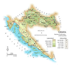
Map of the Gulf of Venice, Adriatic Sea (Engraving, 1717)
")
![]()
Wall Art and Photo Gifts from Fine Art Finder
Map of the Gulf of Venice, Adriatic Sea (Engraving, 1717)
LRI4713002 Map of the Gulf of Venice, Adriatic Sea (Engraving, 1717) by Nolin, Jean-Baptiste (c.1657-1708); Private Collection; (add.info.: Map of the Gulf of Venice (Adriatic Sea), with the coasts of the Republic of Venice (Italy) and the peninsula of Istria (Croatia) - Engraving from the atlas le theatre du monde, 1717, by Jean Baptiste Nolin (1686-1762) - Map of the Gulf of Venice, Adriatic Sea - From " Le Theatre du Monde" 1717 by Jean-Baptiste Nolin); Luisa Ricciarini; French, out of copyright
Media ID 22464600
© Luisa Ricciarini / Bridgeman Images
Atlas Book Geographical Map Venetie
FEATURES IN THESE COLLECTIONS
> Arts
> Artists
> Related Images
> Europe
> Italy
> Veneto
> Venice
> Fine Art Finder
> Artists
> Anonymous
> Fine Art Finder
> Artists
> Jean-Baptiste Nolin
> Maps and Charts
> Italy
EDITORS COMMENTS
This engraving, titled "Map of the Gulf of Venice, Adriatic Sea" takes us back to the year 1717. Created by Jean-Baptiste Nolin, a renowned cartographer of his time, this map offers a detailed and intricate depiction of the Republic of Venice's coasts in Italy and the peninsula of Istria in Croatia. Part of Nolin's famous atlas "Le Theatre du Monde" this print showcases his exceptional skill in capturing geographical accuracy. The Gulf of Venice is beautifully illustrated with its surrounding territories, allowing viewers to immerse themselves in the rich history and significance of these coastal regions. The map not only serves as an informative tool but also stands as a work of art. Its delicate engravings highlight every contour and feature with precision, revealing Nolin's dedication to both functionality and aesthetics. The attention to detail is evident throughout; from small islands dotting the Adriatic Sea to intricate border designs that enhance its visual appeal. As we gaze upon this historical artifact preserved within a private collection, we are transported back centuries ago when exploration was at its peak. It reminds us how maps were once invaluable resources for sailors navigating treacherous waters and merchants seeking new trade routes. Luisa Ricciarini has captured this remarkable piece through her lens, immortalizing it for generations to come. This photograph allows us to appreciate not only Nolin's craftsmanship but also Ricciarini's talent in preserving cultural heritage through her artwork.
MADE IN THE UK
Safe Shipping with 30 Day Money Back Guarantee
FREE PERSONALISATION*
We are proud to offer a range of customisation features including Personalised Captions, Color Filters and Picture Zoom Tools
SECURE PAYMENTS
We happily accept a wide range of payment options so you can pay for the things you need in the way that is most convenient for you
* Options may vary by product and licensing agreement. Zoomed Pictures can be adjusted in the Basket.