
Canvas Print > Universal Images Group (UIG) > Universal Images Group > Satellite and Aerial > Planet Observer 4
Canvas Print : South Sudan, Relief Map with Border and Mask


![]()
Canvas Prints from Universal Images Group (UIG)
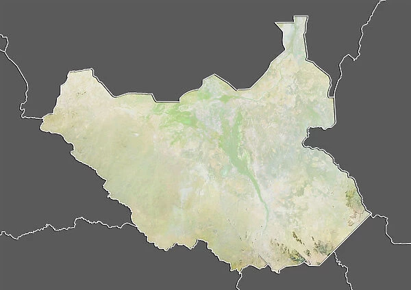
South Sudan, Relief Map with Border and Mask
Relief map of South Sudan (with border and mask). This image was compiled from data acquired by landsat 5 & 7 satellites combined with elevation data
Universal Images Group (UIG) manages distribution for many leading specialist agencies worldwide
Media ID 9613385
© Planet Observer/UIG
Africa Relief Map South Sudan Juba Satellite View
20"x16" (50x40cm) Canvas Print
Discover the beauty and complexity of South Sudan with our Canvas Prints from Media Storehouse. This stunning Relief Map of South Sudan, featuring intricate border details and a mask design, is meticulously created using data from Landsat 5 & 7 satellites and elevation information. Bring the rich geography of this fascinating region into your home or office with our high-quality canvas prints, sure to make a captivating conversation starter.
Ready to hang Premium Gloss Canvas Print. Our archival quality canvas prints are made from Polyester and Cotton mix and stretched over a 1.25" (32mm) kiln dried knot free wood stretcher bar. Packaged in a plastic bag and secured to a cardboard insert for transit.
Canvas Prints add colour, depth and texture to any space. Professionally Stretched Canvas over a hidden Wooden Box Frame and Ready to Hang
Estimated Product Size is 50.8cm x 40.6cm (20" x 16")
These are individually made so all sizes are approximate
Artwork printed orientated as per the preview above, with landscape (horizontal) orientation to match the source image.
EDITORS COMMENTS
This print showcases the intricate details of South Sudan's relief map, complete with borders and a mask. Created using data acquired by landsat 5 & 7 satellites combined with elevation data, this image offers a unique perspective on the physical geography of Africa's youngest nation. The topography is beautifully depicted in vibrant colors, allowing viewers to appreciate the diverse landscapes that make up South Sudan. The horizontal composition of the photograph enhances its visual appeal, while also emphasizing the vastness of this African nation. With no people present in the frame, all attention is directed towards the natural beauty and complexity of South Sudan's terrain. One striking feature captured in this image is the White Nile River meandering through the landscape. Its presence not only adds an element of serenity but also highlights how crucial water resources are for sustaining life within this region. As a piece of cartography artistry, this print serves as both an educational tool and a stunning decorative item. It allows viewers to explore and understand South Sudan's geographical features from afar while appreciating its aesthetic value up close
MADE IN THE UK
Safe Shipping with 30 Day Money Back Guarantee
FREE PERSONALISATION*
We are proud to offer a range of customisation features including Personalised Captions, Color Filters and Picture Zoom Tools
SECURE PAYMENTS
We happily accept a wide range of payment options so you can pay for the things you need in the way that is most convenient for you
* Options may vary by product and licensing agreement. Zoomed Pictures can be adjusted in the Basket.