Canvas Print > Universal Images Group (UIG) > Universal Images Group > Satellite and Aerial > Planet Observer 4
Canvas Print : Senegal, Relief Map With Border and Mask


![]()
Canvas Prints from Universal Images Group (UIG)
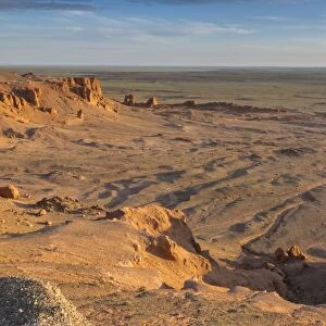
Senegal, Relief Map With Border and Mask
Relief map of Senegal (with border and mask). This image was compiled from data acquired by landsat 5 & 7 satellites combined with elevation data
Universal Images Group (UIG) manages distribution for many leading specialist agencies worldwide
Media ID 9618673
© Planet Observer/UIG
Africa Atlantic Ocean Coastline Relief Map Senegal Shore Dakar Satellite View Senegal River
20"x16" (50x40cm) Canvas Print
Discover the beauty of Senegal with our exquisite Canvas Prints from Media Storehouse. Featuring a captivating relief map of Senegal, this print showcases intricate details of the country's borders and traditional masks. Compiled from high-resolution satellite data from Landsat 5 & 7, this stunning representation is a testament to the power of modern technology and the wonders of our diverse world. Bring this unique piece into your home or office and let it serve as a conversation starter and a reminder of the rich cultural heritage of Senegal.
Ready to hang Premium Gloss Canvas Print. Our archival quality canvas prints are made from Polyester and Cotton mix and stretched over a 1.25" (32mm) kiln dried knot free wood stretcher bar. Packaged in a plastic bag and secured to a cardboard insert for transit.
Canvas Prints add colour, depth and texture to any space. Professionally Stretched Canvas over a hidden Wooden Box Frame and Ready to Hang
Estimated Product Size is 50.8cm x 40.6cm (20" x 16")
These are individually made so all sizes are approximate
Artwork printed orientated as per the preview above, with landscape (horizontal) orientation to match the source image.
EDITORS COMMENTS
This print showcases the stunning relief map of Senegal, adorned with a border and mask. The image is a result of combining data acquired by Landsat 5 & 7 satellites along with elevation data, providing an incredibly detailed representation of the country's topography. The photograph captures the vastness and diversity of Senegal's landscape, stretching from its beautiful coastline along the Atlantic Ocean to its inland regions. The intricate network of rivers, including the majestic Senegal River and Casamance River, can be seen meandering through the terrain. With Dakar as its capital city, Senegal boasts a rich cultural heritage that is deeply rooted in its physical geography. This image serves as a visual testament to this connection between land and people. The horizontal composition allows for an immersive viewing experience, inviting viewers to explore every nook and cranny of this remarkable relief map. Its vibrant colors bring life to the otherwise untouched scenery while emphasizing each geographical feature. As we gaze upon this awe-inspiring photograph, it becomes evident that Universal Images Group (UIG) has masterfully captured not only the beauty but also the scientific significance behind cartography and satellite imagery. This particular artwork beautifully combines artistry with technology to create an extraordinary piece that celebrates both nature's wonders and human ingenuity in mapping our world accurately.
MADE IN THE UK
Safe Shipping with 30 Day Money Back Guarantee
FREE PERSONALISATION*
We are proud to offer a range of customisation features including Personalised Captions, Color Filters and Picture Zoom Tools
SECURE PAYMENTS
We happily accept a wide range of payment options so you can pay for the things you need in the way that is most convenient for you
* Options may vary by product and licensing agreement. Zoomed Pictures can be adjusted in the Basket.