Canvas Print > Europe > United Kingdom > England > Maps
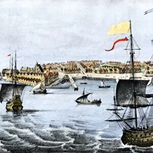
Canvas Print : Map of colonial Rhode Island, 1660s


![]()
Canvas Prints from North Wind
Map of colonial Rhode Island, 1660s
Map of Rhode Island, showing the disputed colonial boundaries, 1660s.
Hand-colored woodcut of a 19th-century illustration
North Wind Picture Archives brings history to life with stock images and hand-colored illustrations
Media ID 5882527
© North Wind Picture Archives
1600s 17th Century Atlantic Atlantic Ocean Colonial Colony New England Ocean Plan Rhode Island Settlement 1660s Narragansett Bay
20"x20" (50x50cm) Canvas Print
Step back in time with our exquisite Canvas Print of a Map of Colonial Rhode Island from the 1660s, available in the Media Storehouse collection. This intricately detailed, hand-colored woodcut illustration from North Wind Picture Archives transports you back to the early colonial era. Disputed boundaries are clearly marked, offering a fascinating glimpse into the complex history of Rhode Island's founding. Elevate your home or office décor with this captivating piece of historical art and relive the stories of the past.
Ready to hang Premium Gloss Canvas Print. Our archival quality canvas prints are made from Polyester and Cotton mix and stretched over a 1.25" (32mm) kiln dried knot free wood stretcher bar. Packaged in a plastic bag and secured to a cardboard insert for transit.
Canvas Prints add colour, depth and texture to any space. Professionally Stretched Canvas over a hidden Wooden Box Frame and Ready to Hang
Estimated Product Size is 50.8cm x 50.8cm (20" x 20")
These are individually made so all sizes are approximate
Artwork printed orientated as per the preview above, with landscape (horizontal) or portrait (vertical) orientation to match the source image.
FEATURES IN THESE COLLECTIONS
> Arts
> Artists
> O
> Oceanic Oceanic
> Europe
> United Kingdom
> England
> Maps
> Historic
> Colonial America illustrations
> Colonial America
> Historic
> Colonial America illustrations
> Historic
> Colonial history
> Colonial art and artists
> North America
> Related Images
> Popular Themes
> North Island
> North Wind Picture Archives
> Maps
EDITORS COMMENTS
This print showcases a remarkable piece of history - the Map of colonial Rhode Island from the 1660s. Hand-colored and created in the 19th century, this woodcut illustration beautifully captures the essence of a bygone era. The map depicts Rhode Island with its disputed colonial boundaries, providing a fascinating glimpse into the complexities of early American settlement. As we gaze upon this vintage artwork, we are transported back to a time when oceanic voyages were arduous yet essential for exploration and expansion. Rhode Island's rich heritage is vividly portrayed through this intricate illustration. The map highlights Narragansett Bay, an iconic feature that played a significant role in shaping the state's history and culture. We can almost feel the Atlantic breeze as we immerse ourselves in this visual representation of life during the 17th century. Every detail on this map tells a story - from each meticulously drawn settlement to every stroke that brings out its traditional charm. It serves as both an educational tool and a work of art, allowing us to appreciate how our nation evolved over time. As we admire this piece, let us reflect on how far we have come since those early days of colonization. This Map of colonial Rhode Island reminds us not only of our roots but also encourages us to cherish our shared past as part of North America's united states.
MADE IN THE UK
Safe Shipping with 30 Day Money Back Guarantee
FREE PERSONALISATION*
We are proud to offer a range of customisation features including Personalised Captions, Color Filters and Picture Zoom Tools
SECURE PAYMENTS
We happily accept a wide range of payment options so you can pay for the things you need in the way that is most convenient for you
* Options may vary by product and licensing agreement. Zoomed Pictures can be adjusted in the Basket.