Antique Framed Print > Europe > United Kingdom > England > Maps
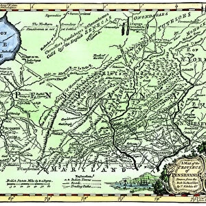
Antique Framed Print : Map of colonial Rhode Island, 1660s


![]()
Framed Photos from North Wind
Map of colonial Rhode Island, 1660s
Map of Rhode Island, showing the disputed colonial boundaries, 1660s.
Hand-colored woodcut of a 19th-century illustration
North Wind Picture Archives brings history to life with stock images and hand-colored illustrations
Media ID 5882527
© North Wind Picture Archives
1600s 17th Century Atlantic Atlantic Ocean Colonial Colony New England Ocean Plan Rhode Island Settlement 1660s Narragansett Bay
18"x18" (46x46cm) Antique Frame
Bevelled wood effect frame, card mounted, 12x12 archival quality photo print. Overall outside dimensions 18x18 inches (46x46cm). Environmentally and ozone friendly, Polycore® moulding has the look of real wood, is durable and light and easy to hang. Biodegradable and made with non-chlorinated gases (no toxic fumes) it is efficient; producing 100 tons of polystyrene can save 300 tons of trees! Prints are glazed with lightweight, shatterproof, optical clarity acrylic (providing the same general protection from the environment as glass). The back is stapled hardboard with a sawtooth hanger attached. Note: To minimise original artwork cropping, for optimum layout, and to ensure print is secure, the visible print may be marginally smaller
Bevelled Wood Effect Framed and Mounted Prints - Professionally Made and Ready to Hang
Estimated Image Size (if not cropped) is 29.4cm x 28.8cm (11.6" x 11.3")
Estimated Product Size is 46.5cm x 46.5cm (18.3" x 18.3")
These are individually made so all sizes are approximate
Artwork printed orientated as per the preview above, with landscape (horizontal) orientation to match the source image.
FEATURES IN THESE COLLECTIONS
> Arts
> Artists
> O
> Oceanic Oceanic
> Europe
> United Kingdom
> England
> Maps
> Historic
> Colonial America illustrations
> Colonial America
> Historic
> Colonial America illustrations
> Historic
> Colonial history
> Colonial art and artists
> North America
> Related Images
> Popular Themes
> North Island
> North Wind Picture Archives
> Maps
EDITORS COMMENTS
This print showcases a remarkable piece of history - the Map of colonial Rhode Island from the 1660s. Hand-colored and created in the 19th century, this woodcut illustration beautifully captures the essence of a bygone era. The map depicts Rhode Island with its disputed colonial boundaries, providing a fascinating glimpse into the complexities of early American settlement. As we gaze upon this vintage artwork, we are transported back to a time when oceanic voyages were arduous yet essential for exploration and expansion. Rhode Island's rich heritage is vividly portrayed through this intricate illustration. The map highlights Narragansett Bay, an iconic feature that played a significant role in shaping the state's history and culture. We can almost feel the Atlantic breeze as we immerse ourselves in this visual representation of life during the 17th century. Every detail on this map tells a story - from each meticulously drawn settlement to every stroke that brings out its traditional charm. It serves as both an educational tool and a work of art, allowing us to appreciate how our nation evolved over time. As we admire this piece, let us reflect on how far we have come since those early days of colonization. This Map of colonial Rhode Island reminds us not only of our roots but also encourages us to cherish our shared past as part of North America's united states.
MADE IN THE UK
Safe Shipping with 30 Day Money Back Guarantee
FREE PERSONALISATION*
We are proud to offer a range of customisation features including Personalised Captions, Color Filters and Picture Zoom Tools
SECURE PAYMENTS
We happily accept a wide range of payment options so you can pay for the things you need in the way that is most convenient for you
* Options may vary by product and licensing agreement. Zoomed Pictures can be adjusted in the Basket.