Canvas Print > Arts > Artists > S > John Speed
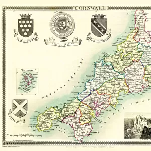
Canvas Print : Old County Map of Cornwall 1611 by John Speed


![]()
Canvas Prints from MapSeeker
Old County Map of Cornwall 1611 by John Speed
A facimile of John Speeds historical map of Cornwall originally published for the " Theatre of the Empire of Great Britain", an atlas to accompany " a history of Great Britain"
Welcome to the Mapseeker Image library and enter an historic gateway to one of the largest on-line collections of Historic Maps, Nostalgic Views, Vista's and Panorama's from a World gone by.
Media ID 20348237
© Mapseeker Publishing Ltd
County Map County Map Of England English County Map Historic Map John Speed Map Old County Map Old English County Map Speed Map Speede Map
20"x16" (50x40cm) Canvas Print
Introducing the Old County Map of Cornwall 1611 by John Speed, now available as a stunning Canvas Print from Media Storehouse. This exquisite replica is a faithful reproduction of the original map published in John Speed's seminal work, "Theatre of the Empire of Great Britain." Dating back to 1611, this historical map provides an intriguing glimpse into the past, showcasing the counties, towns, and landmarks of Cornwall during the early modern period. With its meticulous attention to detail and vivid colors, our Canvas Print brings the rich history of Cornwall to life in your home or office. Order yours today and let the stories of yesteryears unfold before your eyes. (MapSeeker, your trusted source for historical maps, grants us the privilege to reproduce and sell these magnificent pieces of cartographic history as Canvas Prints.)
Ready to hang Premium Gloss Canvas Print. Our archival quality canvas prints are made from Polyester and Cotton mix and stretched over a 1.25" (32mm) kiln dried knot free wood stretcher bar. Packaged in a plastic bag and secured to a cardboard insert for transit.
Canvas Prints add colour, depth and texture to any space. Professionally Stretched Canvas over a hidden Wooden Box Frame and Ready to Hang
Estimated Product Size is 50.8cm x 40.6cm (20" x 16")
These are individually made so all sizes are approximate
Artwork printed orientated as per the preview above, with landscape (horizontal) orientation to match the source image.
FEATURES IN THESE COLLECTIONS
> Arts
> Artists
> S
> John Speed
> Europe
> United Kingdom
> England
> Cornwall
> Related Images
> Europe
> United Kingdom
> England
> Maps
> Maps and Charts
> British Empire Maps
> Maps and Charts
> Early Maps
> Maps and Charts
> Related Images
> MapSeeker
> Maps from the British Isles
> England and Counties PORTFOLIO
EDITORS COMMENTS
This print showcases the "Old County Map of Cornwall 1611" by John Speed, a remarkable facsimile of his historical map originally published for the "Theatre of the Empire of Great Britain". As an exquisite addition to any collection, this English county map offers a glimpse into the rich history and heritage of Cornwall. John Speed's meticulous craftsmanship is evident in every detail, as he intricately depicts the landscape and boundaries of this ancient county. The map serves as both an atlas companion to "A History of Great Britain" and a testament to Speed's dedication in preserving England's past. Transport yourself back in time with this old county map that exudes nostalgia. Its faded hues and delicate lines tell stories from centuries ago, inviting you to explore Cornwall's storied past. From its charming coastal towns to its rugged moorlands, each corner holds secrets waiting to be discovered. Whether you are a history enthusiast or simply appreciate fine cartography, this historic Cornwall map will undoubtedly captivate your imagination. Hang it on your wall or display it proudly on your desk; let it transport you through time as you delve into the intricate details that make up this fascinating piece. Uncover the hidden treasures within Cornwall with John Speed's masterpiece - a true gem for anyone who cherishes our shared heritage.
MADE IN THE UK
Safe Shipping with 30 Day Money Back Guarantee
FREE PERSONALISATION*
We are proud to offer a range of customisation features including Personalised Captions, Color Filters and Picture Zoom Tools
SECURE PAYMENTS
We happily accept a wide range of payment options so you can pay for the things you need in the way that is most convenient for you
* Options may vary by product and licensing agreement. Zoomed Pictures can be adjusted in the Basket.