Home > Arts > Photorealistic artworks > Detailed art pieces > Masterful detailing in art
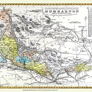
Old Railway Map of The Severn Valley Railway 1887

![]()
Wall Art and Photo Gifts from MapSeeker
Old Railway Map of The Severn Valley Railway 1887
This picturesque image captures the scenic route of the historic Severn Valley Railway as it was during Queen Victorias Golden Jubilee year, 1887. Adjacent railway lines are also detailed along with the Industrial Landscapes of the time. Many coal mines and furnaces that lit up the sky at night are shown around Coalbrookdale and the famous Iron Bridge Gorge, now a World Heritage Site
Welcome to the Mapseeker Image library and enter an historic gateway to one of the largest on-line collections of Historic Maps, Nostalgic Views, Vista's and Panorama's from a World gone by.
Media ID 20347213
FEATURES IN THESE COLLECTIONS
> Animals
> Mammals
> Cricetidae
> Golden Mouse
> Arts
> Artists
> Q
> Queen Victoria Queen Victoria
> Arts
> Photorealistic artworks
> Detailed art pieces
> Masterful detailing in art
> Maps and Charts
> Related Images
> Maps and Charts
> World
> MapSeeker
> Old Railway and Canal Map Collection
> Old Railway Maps PORTFOLIO
> Popular Themes
> Queen Victoria
> Popular Themes
> Railway Posters
EDITORS COMMENTS
This print showcases the Old Railway Map of The Severn Valley Railway in 1887, offering a glimpse into the picturesque and historic route during Queen Victoria's Golden Jubilee year. As one gazes upon this image, they are transported back in time to an era when steam locomotives chugged along these scenic tracks, connecting towns and villages nestled amidst breathtaking landscapes. The map not only highlights the Severn Valley Railway but also provides intricate details of adjacent railway lines that crisscrossed through the region. It offers a fascinating insight into the industrial landscapes of that period, with numerous coal mines and furnaces depicted around Coalbrookdale and the renowned Iron Bridge Gorge – now recognized as a UNESCO World Heritage Site. Imagining this scene at night is truly awe-inspiring; one can almost envision how these coal mines illuminated the sky with their fiery glow, casting an ethereal ambiance over the surrounding countryside. This visual representation serves as a testament to both human ingenuity and nature's beauty coexisting harmoniously. As we explore this remarkable piece of history captured within MapSeeker's photo print, let us appreciate not only its aesthetic appeal but also recognize its significance in preserving our heritage. It reminds us of how railways played a pivotal role in shaping communities while showcasing stunning vistas that continue to captivate hearts even after more than a century has passed.
MADE IN THE UK
Safe Shipping with 30 Day Money Back Guarantee
FREE PERSONALISATION*
We are proud to offer a range of customisation features including Personalised Captions, Color Filters and Picture Zoom Tools
SECURE PAYMENTS
We happily accept a wide range of payment options so you can pay for the things you need in the way that is most convenient for you
* Options may vary by product and licensing agreement. Zoomed Pictures can be adjusted in the Basket.