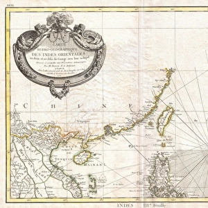
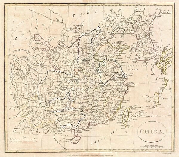
Canvas Print : 1799, Clement Cruttwell Map of China, Korea, and Taiwan, topography, cartography


![]()
Canvas Prints from Liszt Collection
1799, Clement Cruttwell Map of China, Korea, and Taiwan, topography, cartography
1799, Clement Cruttwell Map of China, Korea, and Taiwan
Liszt Collection of nineteenth-century engravings and images to browse and enjoy
Media ID 14004858
© Artokoloro Quint Lox Limited
1799 Korea Antique Map Latitude Longitude Mappa Mundi Old Antique Plan Old Antique View Ols Antique Map Rare Old Maps Topo
20"x16" (50x40cm) Canvas Print
Transport yourself back in time with our exquisite Canvas Print of the 1799 Clement Cruttwell Map of China, Korea, and Taiwan from the esteemed Liszt Collection. This vintage cartographic masterpiece, originally created by renowned mapmaker Clement Cruttwell, offers a captivating glimpse into the topography of East Asia during the late 18th century. The intricate details, vibrant colors, and historical accuracy of this map are beautifully showcased in our high-quality Canvas Print, making it an exceptional addition to any home or office decor. Elevate your space with a touch of history and artistry. Order yours today!
Ready to hang Premium Gloss Canvas Print. Our archival quality canvas prints are made from Polyester and Cotton mix and stretched over a 1.25" (32mm) kiln dried knot free wood stretcher bar. Packaged in a plastic bag and secured to a cardboard insert for transit.
Canvas Prints add colour, depth and texture to any space. Professionally Stretched Canvas over a hidden Wooden Box Frame and Ready to Hang
Estimated Product Size is 50.8cm x 40.6cm (20" x 16")
These are individually made so all sizes are approximate
Artwork printed orientated as per the preview above, with landscape (horizontal) orientation to match the source image.
EDITORS COMMENTS
This print showcases the intricate beauty of the 1799 Clement Cruttwell Map of China, Korea, and Taiwan. A true masterpiece in cartography, this vintage map takes us back in time to an era when exploration and discovery were at their peak. With its topographical details meticulously illustrated, it offers a glimpse into the geographical features of these ancient lands. The artistry displayed on this old paper map is simply awe-inspiring. The carefully crafted grid lines, latitude and longitude markings, and geometric precision demonstrate the immense skill and dedication that went into creating such a historical artifact. As we delve deeper into its rich history, we are transported to a world where navigation relied on maps like these for journeys across vast regions. This rare antique map not only serves as a valuable tool for understanding past civilizations but also doubles as a decorative piece that adds character to any space. Its aged appearance evokes nostalgia while reminding us of our planet's ever-changing landscape throughout time. Whether you are an avid collector or simply appreciate the beauty of historical artifacts, this Clement Cruttwell Map is sure to captivate your imagination with its intricate details and fascinating depiction of China, Korea, and Taiwan from centuries ago.
MADE IN THE UK
Safe Shipping with 30 Day Money Back Guarantee
FREE PERSONALISATION*
We are proud to offer a range of customisation features including Personalised Captions, Color Filters and Picture Zoom Tools
SECURE PAYMENTS
We happily accept a wide range of payment options so you can pay for the things you need in the way that is most convenient for you
* Options may vary by product and licensing agreement. Zoomed Pictures can be adjusted in the Basket.