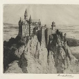
Canvas Print > Europe > United Kingdom > Scotland > Edinburgh > Edinburgh
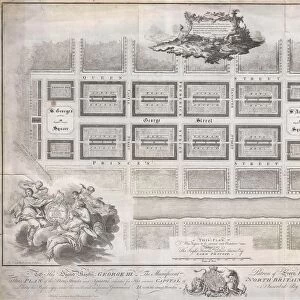
Canvas Print : 1768, James Craig Map of New Town, Edinburgh, Scotland, First Plan of New Town, topography


![]()
Canvas Prints from Liszt Collection
1768, James Craig Map of New Town, Edinburgh, Scotland, First Plan of New Town, topography
1768, James Craig Map of New Town, Edinburgh, Scotland, First Plan of New Town
Liszt Collection of nineteenth-century engravings and images to browse and enjoy
Media ID 14004657
© Artokoloro Quint Lox Limited
1768 Edinburgh Antique Map Latitude Longitude Mappa Mundi Old Antique Plan Old Antique View Ols Antique Map Rare Old Maps Topo
20"x16" (50x40cm) Canvas Print
Introducing the breathtakingly detailed and historically significant "1768, James Craig Map of New Town, Edinburgh, Scotland, First Plan of New Town" from the esteemed Liszt Collection. This exquisite canvas print transports you back in time, offering a captivating glimpse into the architectural wonders of Edinburgh's New Town as it appeared over 250 years ago. James Craig's meticulous topography map showcases the intricate planning and design of this iconic Scottish city, making it a must-have for history enthusiasts and art collectors alike. The high-quality canvas print faithfully reproduces the intricate details of the original map, ensuring that every line and shade is rendered with stunning clarity. Hang this beautiful piece in your home or office as a conversation starter and a testament to the rich history of Edinburgh.
Ready to hang Premium Gloss Canvas Print. Our archival quality canvas prints are made from Polyester and Cotton mix and stretched over a 1.25" (32mm) kiln dried knot free wood stretcher bar. Packaged in a plastic bag and secured to a cardboard insert for transit.
Canvas Prints add colour, depth and texture to any space. Professionally Stretched Canvas over a hidden Wooden Box Frame and Ready to Hang
Estimated Product Size is 50.8cm x 40.6cm (20" x 16")
These are individually made so all sizes are approximate
Artwork printed orientated as per the preview above, with landscape (horizontal) orientation to match the source image.
FEATURES IN THESE COLLECTIONS
> Arts
> Artists
> C
> Craig Craig
> Europe
> France
> Canton
> Landes
> Europe
> United Kingdom
> Heritage Sites
> Old and New Towns of Edinburgh
> Europe
> United Kingdom
> Scotland
> Edinburgh
> Edinburgh
> Europe
> United Kingdom
> Scotland
> Edinburgh
> Europe
> United Kingdom
> Scotland
> Lothian
> Edinburgh
> Europe
> United Kingdom
> Scotland
> Maps
> Europe
> United Kingdom
> Scotland
> Posters
> Europe
> United Kingdom
> Scotland
> Related Images
> Historic
> Space exploration
EDITORS COMMENTS
This print showcases the remarkable 1768 James Craig Map of New Town, Edinburgh, Scotland - a true treasure for history enthusiasts and cartography lovers alike. The First Plan of New Town depicted in this vintage piece offers an immersive journey into the past, allowing us to explore the topography and geography of this iconic Scottish city. With its intricate details and precise measurements, this old map reveals the evolution of Edinburgh's urban landscape during a significant period in history. Its artistic illustration beautifully captures the essence of a bygone era, transporting us back to a time when navigation relied on paper maps rather than modern technology. As we gaze upon this decorative antique map, we are reminded of the importance placed on geographical knowledge and exploration throughout human civilization. It serves as a testament to mankind's innate curiosity about our world and its regions. The aged appearance adds an extra layer of charm to this historic artifact, reminding us that it has witnessed centuries worth of journeys and discoveries. This rare gem from the Liszt Collection is not only an invaluable resource for researchers but also a stunning piece of art that brings history alive within any space fortunate enough to display it.
MADE IN THE UK
Safe Shipping with 30 Day Money Back Guarantee
FREE PERSONALISATION*
We are proud to offer a range of customisation features including Personalised Captions, Color Filters and Picture Zoom Tools
SECURE PAYMENTS
We happily accept a wide range of payment options so you can pay for the things you need in the way that is most convenient for you
* Options may vary by product and licensing agreement. Zoomed Pictures can be adjusted in the Basket.