
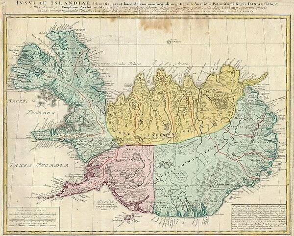
Canvas Print : 1761, Homann Heirs Map of Iceland Insulae Islandiae, topography, cartography, geography


![]()
Canvas Prints from Liszt Collection
1761, Homann Heirs Map of Iceland Insulae Islandiae, topography, cartography, geography
1761, Homann Heirs Map of Iceland Insulae Islandiae
Liszt Collection of nineteenth-century engravings and images to browse and enjoy
Media ID 14004628
© Artokoloro Quint Lox Limited
1761 Antique Map Latitude Longitude Mappa Mundi Old Antique Plan Old Antique View Ols Antique Map Rare Old Maps Topo
20"x16" (50x40cm) Canvas Print
Step into the captivating world of cartography and geography with Media Storehouse's Canvas Prints. This exquisite piece showcases the intricately detailed 1761 Homann Heirs Map of Iceland, Insulae Islandiae. Originating from the esteemed Liszt Collection, this vintage map offers a unique glimpse into the topography and history of Iceland. The rich, vibrant colors and crisp lines of the map are beautifully accentuated on the high-quality canvas, creating a stunning art piece that adds character and depth to any room. Bring a piece of historical cartography into your home or office and transport yourself back in time with Media Storehouse's Canvas Prints.
Ready to hang Premium Gloss Canvas Print. Our archival quality canvas prints are made from Polyester and Cotton mix and stretched over a 1.25" (32mm) kiln dried knot free wood stretcher bar. Packaged in a plastic bag and secured to a cardboard insert for transit.
Canvas Prints add colour, depth and texture to any space. Professionally Stretched Canvas over a hidden Wooden Box Frame and Ready to Hang
Estimated Product Size is 50.8cm x 40.6cm (20" x 16")
These are individually made so all sizes are approximate
Artwork printed orientated as per the preview above, with landscape (horizontal) orientation to match the source image.
EDITORS COMMENTS
This print showcases the Homann Heirs Map of Iceland Insulae Islandiae, a true masterpiece in topography, cartography, and geography. Created in 1761, this vintage map takes us on a journey through time, offering a glimpse into the ancient world of exploration and discovery. The intricate details depicted on this map are truly remarkable. From the carefully drawn landforms to the precise grid lines marking latitude and longitude, every element is meticulously crafted. The geometric precision used in creating this map demonstrates not only its functionality as a navigational tool but also its artistic value. As we gaze upon this historical artifact, we can't help but be transported back to an era when maps were essential for understanding our planet's vast regions. Its aged appearance adds to its charm and reminds us of the rich history that lies within its delicate paper. This rare old map serves as a window into Iceland's past, allowing us to explore its unique geographical features and appreciate the artistry behind it. It is more than just an illustration; it represents centuries of knowledge and curiosity about our world. Whether you are an avid collector or simply fascinated by history, this Homann Heirs Map of Iceland Insulae Islandiae will surely captivate your imagination with its beauty and significance.
MADE IN THE UK
Safe Shipping with 30 Day Money Back Guarantee
FREE PERSONALISATION*
We are proud to offer a range of customisation features including Personalised Captions, Color Filters and Picture Zoom Tools
SECURE PAYMENTS
We happily accept a wide range of payment options so you can pay for the things you need in the way that is most convenient for you
* Options may vary by product and licensing agreement. Zoomed Pictures can be adjusted in the Basket.

