Canvas Print > Historic > Space exploration > Moon landing
Canvas Print : Geological map of the moon, 1967


![]()
Canvas Prints from Heritage Images
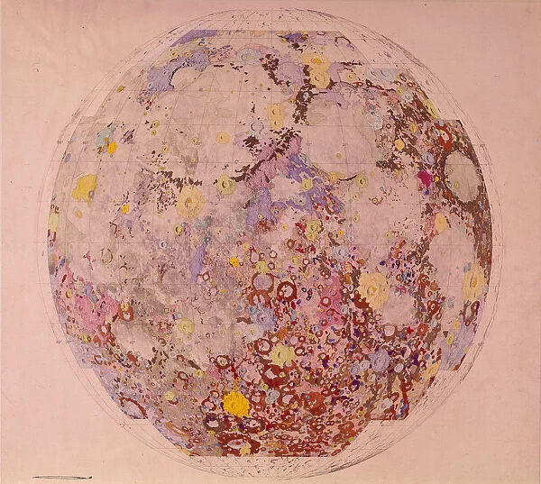
Geological map of the moon, 1967
Geological map of the moon, 1967. This map is based largely on photographs taken by the US Lunar Orbiter 4 spacecraft. Launched on 4 May 1967, Lunar Orbiter 4 was the fourth in a series of five spacecraft designed to assist in the selection of Apollo manned moon landing sites in the equatorial region from 43 degrees east to 56 degrees west
Heritage Images features heritage image collections
Media ID 14863107
© NASA/Oxford Science Archive / Heritage-Images
Exploration Geology Lunar Moon Nasa Orbit Oxford Science Archive Planet Space
20"x16" (50x40cm) Canvas Print
Step into the realm of lunar exploration with our captivating Canvas Print of the Geological Map of the Moon, 1967. This vintage piece of space history, sourced from Heritage Images, brings you closer to the lunar terrain as it was understood in the late 1960s. Based on photographs taken by the US Lunar Orbiter 4 spacecraft, this unique canvas print makes a striking addition to any room, igniting conversations and fueling curiosity about our celestial neighbor. Embrace the spirit of discovery and bring the wonders of space into your home.
Ready to hang Premium Gloss Canvas Print. Our archival quality canvas prints are made from Polyester and Cotton mix and stretched over a 1.25" (32mm) kiln dried knot free wood stretcher bar. Packaged in a plastic bag and secured to a cardboard insert for transit.
Canvas Prints add colour, depth and texture to any space. Professionally Stretched Canvas over a hidden Wooden Box Frame and Ready to Hang
Estimated Product Size is 50.8cm x 40.6cm (20" x 16")
These are individually made so all sizes are approximate
Artwork printed orientated as per the preview above, with landscape (horizontal) orientation to match the source image.
FEATURES IN THESE COLLECTIONS
> Historic
> Space exploration
> Moon landing
> Historic
> Space exploration
> NASA history
> Historic
> Space exploration
> Maps and Charts
> Geological Map
> Maps and Charts
> Related Images
> Science
> Space Exploration
> The Moon
> Science
> Space Exploration
> Related Images
> Science
> Space Exploration
> Solar System
EDITORS COMMENTS
This print showcases a remarkable geological map of the moon, created in 1967. Based on photographs taken by the US Lunar Orbiter 4 spacecraft, this map played a crucial role in selecting potential landing sites for Apollo missions. Launched on May 4th, 1967, Lunar Orbiter 4 was part of a series of five spacecraft designed to explore and study the moon's equatorial region from 43 degrees east to 56 degrees west. The image captures the essence of scientific exploration and human curiosity as it reveals intricate details about our celestial neighbor. The vibrant colors used in this print bring life to the lunar surface, highlighting its diverse geology and natural phenomena. As we gaze upon this mesmerizing artwork, we are transported back to an era when space exploration was at its peak. It serves as a testament to humanity's relentless pursuit of knowledge beyond our planet and reminds us of the groundbreaking achievements made during that time. This extraordinary piece is not only an ode to science but also a symbol of how far we have come in understanding our place within the vastness of space. Created by an unknown artist and preserved by Oxford Science Archive, this print stands as a tribute to NASA's pioneering efforts and their invaluable contributions towards unraveling the mysteries of our solar system.
MADE IN THE UK
Safe Shipping with 30 Day Money Back Guarantee
FREE PERSONALISATION*
We are proud to offer a range of customisation features including Personalised Captions, Color Filters and Picture Zoom Tools
SECURE PAYMENTS
We happily accept a wide range of payment options so you can pay for the things you need in the way that is most convenient for you
* Options may vary by product and licensing agreement. Zoomed Pictures can be adjusted in the Basket.