Canvas Print > Granger Art on Demand > Maps
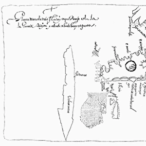
Canvas Print : MAP OF NORTH AMERICA, 1585. John Whites map of Americas eastern coast from Chesapeake


![]()
Canvas Prints from Granger
MAP OF NORTH AMERICA, 1585. John Whites map of Americas eastern coast from Chesapeake
MAP OF NORTH AMERICA, 1585.
John Whites map of Americas eastern coast from Chesapeake to Florida, 1585
Granger holds millions of images spanning more than 25,000 years of world history, from before the Stone Age to the dawn of the Space Age
Media ID 12321038
1585 Age Of Discovery Atlantic Ocean Chesapeake Bay Coast Colony Eastern Florida New World Seashore United States White Southeast
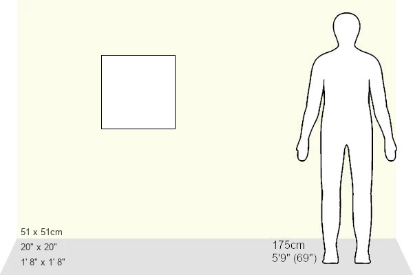
20"x20" (50x50cm) Canvas Print
Discover the rich history of North America with our stunning Canvas Print of John White's 1585 map of the eastern coast from Chesapeake to Florida. This captivating piece, sourced from Granger Art on Demand, showcases intricate details of the unexplored lands as they were perceived during the late 16th century. Bring history to life in your home or office with this beautifully printed and expertly crafted canvas, perfect for history enthusiasts and cartography lovers alike.
Ready to hang Premium Gloss Canvas Print. Our archival quality canvas prints are made from Polyester and Cotton mix and stretched over a 1.25" (32mm) kiln dried knot free wood stretcher bar. Packaged in a plastic bag and secured to a cardboard insert for transit.
Canvas Prints add colour, depth and texture to any space. Professionally Stretched Canvas over a hidden Wooden Box Frame and Ready to Hang
Estimated Product Size is 50.8cm x 50.8cm (20" x 20")
These are individually made so all sizes are approximate
Artwork printed orientated as per the preview above, with landscape (horizontal) or portrait (vertical) orientation to match the source image.
MAP OF NORTH AMERICA, 1585 - A Glimpse into the Age of Discovery
EDITORS COMMENTS
. This print takes us back to the late Renaissance period and offers a fascinating glimpse into John White's map of America's eastern coast from Chesapeake to Florida in 1585. As we explore this intricate cartographic masterpiece, we are transported to an era when intrepid explorers set sail across the vast Atlantic Ocean in search of new worlds. The map showcases North America's untamed beauty, with its sprawling coastline stretching from Chesapeake Bay all the way down to Florida. It serves as a testament to the early European colonization efforts and highlights key landmarks such as rivers, seashores, and colonies that played pivotal roles in shaping the future United States. With every detail meticulously captured on this print, it is evident that John White possessed an exceptional talent for cartography. His work not only served practical purposes but also ignited curiosity about these uncharted territories among his contemporaries. As we admire this historical artifact, let us appreciate how it symbolizes human curiosity and ambition during a time when venturing into unknown lands was both thrilling and perilous. This remarkable piece invites us to reflect upon our collective past while celebrating the spirit of exploration that continues to drive humanity forward even today.
MADE IN THE UK
Safe Shipping with 30 Day Money Back Guarantee
FREE PERSONALISATION*
We are proud to offer a range of customisation features including Personalised Captions, Color Filters and Picture Zoom Tools
SECURE PAYMENTS
We happily accept a wide range of payment options so you can pay for the things you need in the way that is most convenient for you
* Options may vary by product and licensing agreement. Zoomed Pictures can be adjusted in the Basket.