Canvas Print > Europe > Germany > Maps
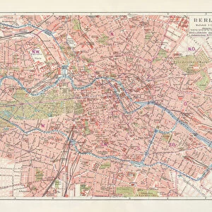
Canvas Print : Map of Berlin 1895


![]()
Canvas Prints from Fine Art Storehouse
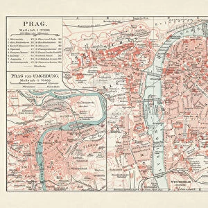
Map of Berlin 1895
Map of Berlin (surroundings), Germany
Unleash your creativity and transform your space into a visual masterpiece!
THEPALMER
Media ID 13613671
© Roberto A Sanchez
62990 Berlin Dictionary Earth Globe Navigational Equipment Retro Styled
20"x16" (50x40cm) Canvas Print
Introducing the captivating "Map of Berlin 1895" by THEPALMER from our Media Storehouse Canvas Prints collection. This exquisite piece of historical art takes you on a journey back in time, showcasing the intricate details of Berlin and its surroundings in Germany during the late 19th century. The rich, vibrant colors and meticulous detailing bring the map to life, making it a stunning addition to any room in your home or office. The high-quality canvas print is professionally crafted to ensure a long-lasting, museum-quality finish. Transport yourself back in time with this beautiful and educational piece of art.
Ready to hang Premium Gloss Canvas Print. Our archival quality canvas prints are made from Polyester and Cotton mix and stretched over a 1.25" (32mm) kiln dried knot free wood stretcher bar. Packaged in a plastic bag and secured to a cardboard insert for transit.
Canvas Prints add colour, depth and texture to any space. Professionally Stretched Canvas over a hidden Wooden Box Frame and Ready to Hang
Estimated Product Size is 50.8cm x 40.6cm (20" x 16")
These are individually made so all sizes are approximate
Artwork printed orientated as per the preview above, with landscape (horizontal) orientation to match the source image.
FEATURES IN THESE COLLECTIONS
> Europe
> Germany
> Related Images
> Maps and Charts
> Related Images
> Fine Art Storehouse
> The Magical World of Illustration
> Palmer Illustrated Collection
> Fine Art Storehouse
> Map
> Historical Maps
EDITORS COMMENTS
This print showcases a mesmerizing piece of history - the Map of Berlin from 1895. With its retro-styled, antique appearance, this engraved image takes us back in time to explore the physical geography and layout of Germany's capital city during that era. The intricate details and craftsmanship evident in this engraving are truly remarkable. The Map of Berlin 1895 is a testament to the artistry and precision involved in cartography. Every street, building, and landmark is meticulously depicted, offering a glimpse into what life was like in this bustling metropolis over a century ago. As we study this old map, we can't help but marvel at how much has changed since then. The horizontal composition allows for an immersive viewing experience as our eyes wander across the globe navigational equipment featured alongside the map. This combination serves as a reminder of humanity's eternal quest for exploration and discovery. Photographed by THEPALMER with great attention to detail in 2015, this print captures not only the historical significance but also preserves it for future generations to appreciate. Whether you're an avid collector or simply fascinated by vintage maps and their stories, this enchanting artwork will transport you back in time to discover Berlin's past like never before.
MADE IN THE UK
Safe Shipping with 30 Day Money Back Guarantee
FREE PERSONALISATION*
We are proud to offer a range of customisation features including Personalised Captions, Color Filters and Picture Zoom Tools
SECURE PAYMENTS
We happily accept a wide range of payment options so you can pay for the things you need in the way that is most convenient for you
* Options may vary by product and licensing agreement. Zoomed Pictures can be adjusted in the Basket.