Canvas Print > Fine Art Storehouse > Map
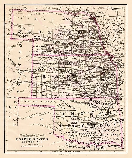
Canvas Print : Kansas and Nebraska map 1881


![]()
Canvas Prints from Fine Art Storehouse
Kansas and Nebraska map 1881
Coltons Common School Geography 1881 New York Sheldon and Co
Unleash your creativity and transform your space into a visual masterpiece!
THEPALMER
Media ID 13669271
© This content is subject to copyright
American Culture Globe Navigational Equipment Kansas Nebraska North America Paper Planet Earth World Map
20"x16" (50x40cm) Canvas Print
Step back in time with our exquisite Canvas Print of the Kansas and Nebraska Map from 1881, brought to you by THEPALMER from our Media Storehouse Fine Art collection. This captivating piece, originally published by Colton's Common School Geography in New York by Sheldon and Co, showcases the historical territories of Kansas and Nebraska in intricate detail. Perfect for history enthusiasts, educators, or those who appreciate the beauty of vintage maps, this Canvas Print adds a touch of nostalgia and character to any room. Experience the rich history of the American Midwest with this stunning and authentic work of art.
Ready to hang Premium Gloss Canvas Print. Our archival quality canvas prints are made from Polyester and Cotton mix and stretched over a 1.25" (32mm) kiln dried knot free wood stretcher bar. Packaged in a plastic bag and secured to a cardboard insert for transit.
Canvas Prints add colour, depth and texture to any space. Professionally Stretched Canvas over a hidden Wooden Box Frame and Ready to Hang
Estimated Product Size is 40.6cm x 50.8cm (16" x 20")
These are individually made so all sizes are approximate
Artwork printed orientated as per the preview above, with portrait (vertical) orientation to match the source image.
FEATURES IN THESE COLLECTIONS
> Fine Art Storehouse
> The Magical World of Illustration
> Palmer Illustrated Collection
> Fine Art Storehouse
> Map
> Historical Maps
> Fine Art Storehouse
> Map
> USA Maps
EDITORS COMMENTS
This print takes us back in time to the year 1881, showcasing a detailed map of Kansas and Nebraska. The map is sourced from Coltons Common School Geography, a renowned publication that served as an educational tool during that era. Printed by Sheldon and Co in New York, this piece represents a significant part of American culture and history. The image transports us to an age when globe navigational equipment was used for exploration and discovery. The old paper texture adds charm to the overall aesthetic, reminding us of the craftsmanship involved in creating such intricate maps. This engraving captures not only the physical geography but also provides insight into the cartography techniques employed at the time. As we gaze upon this antique illustration, we are reminded of how our planet has evolved over time. It serves as a reminder that even though borders may change, our connection with Earth remains constant. The vertical orientation emphasizes North America's vastness while highlighting both Kansas and Nebraska within its boundaries. "TheKansas and Nebraska Map 1881" invites us to appreciate the artistry behind historical cartography while reflecting on how these maps shaped our understanding of geography. This stunning print by THEPALMER is perfect for those who appreciate vintage aesthetics or have an interest in exploring America's past through visual representations like this one.
MADE IN THE UK
Safe Shipping with 30 Day Money Back Guarantee
FREE PERSONALISATION*
We are proud to offer a range of customisation features including Personalised Captions, Color Filters and Picture Zoom Tools
SECURE PAYMENTS
We happily accept a wide range of payment options so you can pay for the things you need in the way that is most convenient for you
* Options may vary by product and licensing agreement. Zoomed Pictures can be adjusted in the Basket.