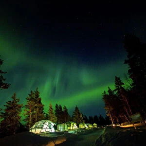
Antique Framed Print > Universal Images Group (UIG) > Universal Images Group > Satellite and Aerial > Planet Observer 6
Antique Framed Print : Western Sahara, Relief Map


![]()
Framed Photos from Universal Images Group (UIG)
Western Sahara, Relief Map
Relief map of Western Sahara. This map was processed from elevation data
Universal Images Group (UIG) manages distribution for many leading specialist agencies worldwide
Media ID 9634169
© Planet Observer
Alsace Bas Rhin Geographical Border Relief Map Satellite View
14"x12" (36x31cm) Antique Frame
Bevelled wood effect frame, card mounted, 10x8 archival quality photo print. Overall outside dimensions 14x12 inches (36x31cm). Environmentally and ozone friendly, the Polycore® moulding has the look of real wood, is durable and light and easy to hang. Biodegradable and made with non-chlorinated gases (no toxic fumes) it is efficient; producing 100 tons of polystyrene can save 300 tons of trees! Prints are glazed with lightweight, shatterproof, optical clarity acrylic (providing the same general protection from the environment as glass). The back is stapled hardboard with a sawtooth hanger attached. Note: To minimise original artwork cropping, for optimum layout, and to ensure print is secure, the visible print may be marginally smaller
Bevelled Wood Effect Framed and Mounted Prints - Professionally Made and Ready to Hang
Estimated Image Size (if not cropped) is 24.4cm x 17.3cm (9.6" x 6.8")
Estimated Product Size is 36.3cm x 31.2cm (14.3" x 12.3")
These are individually made so all sizes are approximate
Artwork printed orientated as per the preview above, with landscape (horizontal) orientation to match the source image.
EDITORS COMMENTS
This print showcases the intricate details of a relief map of Western Sahara, offering a unique perspective on this fascinating region. Processed from elevation data, the map beautifully captures the topography and physical geography of Western Sahara. The vibrant colors and precise cartography make it an excellent tool for studying and understanding the landforms that shape this part of Africa. Taken in Alsace, France by Universal Images Group (UIG), this vertical photograph highlights their exceptional photography skills. With no people present in the frame, all attention is drawn to the relief map itself, allowing viewers to immerse themselves in its intricacies. The satellite view adds another layer of depth to this image as it enables us to appreciate how geographical borders are defined within Western Sahara's vast expanse. The outdoors setting further enhances our connection with nature and reminds us of the importance of preserving such remarkable landscapes. It is worth noting that this caption does not mention any commercial use or affiliation with a specific company but focuses solely on appreciating the beauty and educational value offered by this particular print from Universal Images Group (UIG). Whether you are an enthusiast seeking knowledge about Western Sahara or simply captivated by maps and topography, this stunning image will undoubtedly leave you awe-inspired.
MADE IN THE UK
Safe Shipping with 30 Day Money Back Guarantee
FREE PERSONALISATION*
We are proud to offer a range of customisation features including Personalised Captions, Color Filters and Picture Zoom Tools
SECURE PAYMENTS
We happily accept a wide range of payment options so you can pay for the things you need in the way that is most convenient for you
* Options may vary by product and licensing agreement. Zoomed Pictures can be adjusted in the Basket.