Antique Framed Print > Universal Images Group (UIG) > Universal Images Group > Satellite and Aerial > Planet Observer 4
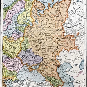
Antique Framed Print : Latvia, Relief Map With Border and Mask


![]()
Framed Photos from Universal Images Group (UIG)
Latvia, Relief Map With Border and Mask
Relief map of Latvia (with border and mask). This image was compiled from data acquired by landsat 5 & 7 satellites combined with elevation data
Universal Images Group (UIG) manages distribution for many leading specialist agencies worldwide
Media ID 9618527
© Planet Observer/UIG
Baltic Region Baltic Sea Coastline Latvia Relief Map Riga Shore Satellite View
14"x12" (36x31cm) Antique Frame
Bevelled wood effect frame, card mounted, 10x8 archival quality photo print. Overall outside dimensions 14x12 inches (36x31cm). Environmentally and ozone friendly, the Polycore® moulding has the look of real wood, is durable and light and easy to hang. Biodegradable and made with non-chlorinated gases (no toxic fumes) it is efficient; producing 100 tons of polystyrene can save 300 tons of trees! Prints are glazed with lightweight, shatterproof, optical clarity acrylic (providing the same general protection from the environment as glass). The back is stapled hardboard with a sawtooth hanger attached. Note: To minimise original artwork cropping, for optimum layout, and to ensure print is secure, the visible print may be marginally smaller
Bevelled Wood Effect Framed and Mounted Prints - Professionally Made and Ready to Hang
Estimated Image Size (if not cropped) is 24.4cm x 17.3cm (9.6" x 6.8")
Estimated Product Size is 36.3cm x 31.2cm (14.3" x 12.3")
These are individually made so all sizes are approximate
Artwork printed orientated as per the preview above, with landscape (horizontal) orientation to match the source image.
EDITORS COMMENTS
This print showcases the stunning relief map of Latvia, a picturesque country nestled in the Baltic region of Europe. With its intricate details and vibrant colors, this image offers a unique perspective on Latvia's physical geography. Compiled from data acquired by landsat 5 & 7 satellites combined with elevation data, this map provides an accurate representation of the country's topography. The photograph beautifully captures Latvia's diverse landscape, featuring its breathtaking coastline along the Baltic Sea. The rugged shorelines and pristine beaches are highlighted against the backdrop of rolling hills and lush forests that dominate much of the country's interior. This visual masterpiece allows viewers to appreciate the natural beauty that Latvia has to offer. With Riga, the capital city, marked prominently on this relief map, one can also observe how urbanization has seamlessly integrated into Latvia's scenic surroundings. The horizontal composition adds depth to this image while emphasizing both human-made structures and untouched natural wonders. As there are no people visible in this photograph, it invites viewers to imagine themselves exploring these enchanting landscapes firsthand. Whether you have an interest in cartography or simply admire captivating photography capturing nature at its finest, this print is sure to transport you into the heart of Latvia’s remarkable terrain
MADE IN THE UK
Safe Shipping with 30 Day Money Back Guarantee
FREE PERSONALISATION*
We are proud to offer a range of customisation features including Personalised Captions, Color Filters and Picture Zoom Tools
SECURE PAYMENTS
We happily accept a wide range of payment options so you can pay for the things you need in the way that is most convenient for you
* Options may vary by product and licensing agreement. Zoomed Pictures can be adjusted in the Basket.