Antique Framed Print > Maps and Charts > Germany
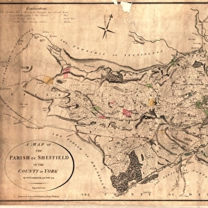
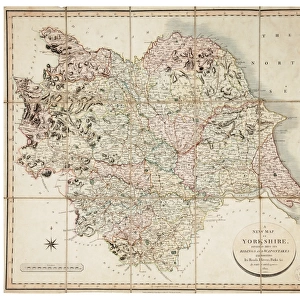
Antique Framed Print : Ordnance Survey map of north Sheffield copied by the Germans, and marked with bombing targets


![]()
Framed Photos from Sheffield City Archives
Ordnance Survey map of north Sheffield copied by the Germans, and marked with bombing targets
Original at Sheffield Local Studiess 26 M/4
Sheffield City Archives and Local Studies Library has an unrivalled collection of images of Sheffield, England
Media ID 14046718
© Sheffield City Council
Attercliffe Brightside Centre City Crookes Cyclops Grimesthorpe Hillsborough Industry Maps Military Owlerton Park Power Reservoirs Stations Steel Valley Walkley Works World Barracks Bombs Godfrey Hadfield Lower Raids Shirecliffe Supply
14"x12" (36x31cm) Antique Frame
Bevelled wood effect frame, card mounted, 10x8 archival quality photo print. Overall outside dimensions 14x12 inches (36x31cm). Environmentally and ozone friendly, the Polycore® moulding has the look of real wood, is durable and light and easy to hang. Biodegradable and made with non-chlorinated gases (no toxic fumes) it is efficient; producing 100 tons of polystyrene can save 300 tons of trees! Prints are glazed with lightweight, shatterproof, optical clarity acrylic (providing the same general protection from the environment as glass). The back is stapled hardboard with a sawtooth hanger attached. Note: To minimise original artwork cropping, for optimum layout, and to ensure print is secure, the visible print may be marginally smaller
Bevelled Wood Effect Framed and Mounted Prints - Professionally Made and Ready to Hang
Estimated Image Size (if not cropped) is 24.4cm x 17.1cm (9.6" x 6.7")
Estimated Product Size is 36.3cm x 31.2cm (14.3" x 12.3")
These are individually made so all sizes are approximate
Artwork printed orientated as per the preview above, with landscape (horizontal) orientation to match the source image.
FEATURES IN THESE COLLECTIONS
> Maps and Charts
> Related Images
> Maps and Charts
> World
> Sheffield City Archives
> Maps and Plans
EDITORS COMMENTS
This print showcases an intriguing piece of history - an Ordnance Survey map of north Sheffield that was copied by the Germans during World War II and marked with bombing targets. The original map can be found at Sheffield Local Studies (26 M/4). The image takes us back to a time when air raids and bombs were a constant threat, reminding us of the immense challenges faced by the people of Sheffield during this tumultuous period. The map highlights significant areas such as Hadfield Dam, reservoirs, Godfrey Old Great Crookes, New Owlerton, City Centre Park, Lower Don Valley, Attercliffe Brightside Steel Industry Atlas Works Cyclops President Grimesthorpe Shirecliffe Power Stations Electricity Supply Hillsborough Barracks Military Walkley. It serves as a poignant reminder of the resilience and strength exhibited by the citizens in safeguarding their city against enemy attacks. This historical artifact not only sheds light on the strategic importance placed on various locations but also offers valuable insights into how communities were affected by war. As we gaze upon this remarkable print from Sheffield City Archives, it is impossible not to appreciate both its historical significance and its ability to transport us back in time. It stands as a testament to the courage displayed by those who lived through these challenging times while providing us with a deeper understanding of Sheffield's rich heritage.
MADE IN THE UK
Safe Shipping with 30 Day Money Back Guarantee
FREE PERSONALISATION*
We are proud to offer a range of customisation features including Personalised Captions, Color Filters and Picture Zoom Tools
SECURE PAYMENTS
We happily accept a wide range of payment options so you can pay for the things you need in the way that is most convenient for you
* Options may vary by product and licensing agreement. Zoomed Pictures can be adjusted in the Basket.