Antique Framed Print > Europe > United Kingdom > Wales > Maps
Antique Framed Print : Map of England in 1066


![]()
Framed Photos from North Wind
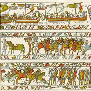
Map of England in 1066
England at the time of the Norman conquest, 1066-1081.
Color lithograph of a 19th-century illustration
North Wind Picture Archives brings history to life with stock images and hand-colored illustrations
Media ID 5879268
© North Wind Picture Archives
1066 11th Century Britain British England English Europe European Feudalism Great Britain Medieval Middle Ages Norman Norman Conquest Norman Invasion North Umberland Wales William The Conqueror Earldom
14"x12" (36x31cm) Antique Frame
Bevelled wood effect frame, card mounted, 10x8 archival quality photo print. Overall outside dimensions 14x12 inches (36x31cm). Environmentally and ozone friendly, the Polycore® moulding has the look of real wood, is durable and light and easy to hang. Biodegradable and made with non-chlorinated gases (no toxic fumes) it is efficient; producing 100 tons of polystyrene can save 300 tons of trees! Prints are glazed with lightweight, shatterproof, optical clarity acrylic (providing the same general protection from the environment as glass). The back is stapled hardboard with a sawtooth hanger attached. Note: To minimise original artwork cropping, for optimum layout, and to ensure print is secure, the visible print may be marginally smaller
Bevelled Wood Effect Framed and Mounted Prints - Professionally Made and Ready to Hang
Estimated Image Size (if not cropped) is 18.5cm x 24.4cm (7.3" x 9.6")
Estimated Product Size is 31.2cm x 36.3cm (12.3" x 14.3")
These are individually made so all sizes are approximate
Artwork printed orientated as per the preview above, with portrait (vertical) orientation to match the source image.
FEATURES IN THESE COLLECTIONS
> Arts
> Art Movements
> Medieval Art
> Europe
> United Kingdom
> England
> Maps
> Europe
> United Kingdom
> Maps
> Europe
> United Kingdom
> Wales
> Maps
> Europe
> United Kingdom
> Wales
> Posters
> Europe
> United Kingdom
> Wales
> Related Images
> Maps and Charts
> Related Images
> Maps and Charts
> Wales
> North Wind Picture Archives
> British history
> North Wind Picture Archives
> Maps
EDITORS COMMENTS
This print showcases a remarkable piece of history - the Map of England in 1066, during the time of the Norman conquest. Created as a color lithograph in the 19th century, this illustration beautifully captures the essence of medieval England. The map takes us back to a bygone era, where kingdoms and earldoms dotted the landscape. It provides an intriguing glimpse into the political and geographical makeup of Great Britain at that time. From Northumberland to Wales, every region is meticulously depicted with intricate details. As we explore this vintage artwork, we can't help but feel connected to our heritage and traditions. The image evokes a sense of nostalgia for a past long gone yet still deeply ingrained within our cultural fabric. It reminds us of William the Conqueror's audacious invasion and subsequent Norman conquest that forever altered British history. This pivotal event marked not only a change in leadership but also introduced feudalism to these lands. Through this artful representation, we are transported back to an age characterized by castles, knights, and chivalry - an era known as the Middle Ages or Dark Ages. It serves as a visual reminder of how far Europe has come since then while honoring its rich historical tapestry. This stunning portrayal invites us to delve deeper into English history and appreciate how it shaped modern-day Britain. Whether displayed in homes or educational institutions, this print is sure to spark curiosity and ignite conversations about our shared past.
MADE IN THE UK
Safe Shipping with 30 Day Money Back Guarantee
FREE PERSONALISATION*
We are proud to offer a range of customisation features including Personalised Captions, Color Filters and Picture Zoom Tools
SECURE PAYMENTS
We happily accept a wide range of payment options so you can pay for the things you need in the way that is most convenient for you
* Options may vary by product and licensing agreement. Zoomed Pictures can be adjusted in the Basket.