Antique Framed Print > Maps and Charts > Abraham Ortelius
Antique Framed Print : Map of American Continent. Theatrum Orbis Terrarum by Abraha


![]()
Framed Photos from Mary Evans Picture Library
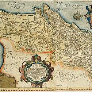
Map of American Continent. Theatrum Orbis Terrarum by Abraha
Map of American Continent. Theatrum Orbis Terrarum by Abraham Ortelius (1527-1598). First Edition. Antwerp, 1574
Mary Evans Picture Library makes available wonderful images created for people to enjoy over the centuries
Media ID 14330270
© Thaliastock / Mary Evans
1574 Abraham Americas Antwerp Atlas Barcelona Cartography Continent Edition Flanders Flemish Geography Monster Orbis Ortelius Ortels Terrarum Theatrum
14"x12" (36x31cm) Antique Frame
Bevelled wood effect frame, card mounted, 10x8 archival quality photo print. Overall outside dimensions 14x12 inches (36x31cm). Environmentally and ozone friendly, the Polycore® moulding has the look of real wood, is durable and light and easy to hang. Biodegradable and made with non-chlorinated gases (no toxic fumes) it is efficient; producing 100 tons of polystyrene can save 300 tons of trees! Prints are glazed with lightweight, shatterproof, optical clarity acrylic (providing the same general protection from the environment as glass). The back is stapled hardboard with a sawtooth hanger attached. Note: To minimise original artwork cropping, for optimum layout, and to ensure print is secure, the visible print may be marginally smaller
Bevelled Wood Effect Framed and Mounted Prints - Professionally Made and Ready to Hang
Estimated Image Size (if not cropped) is 24.4cm x 17.8cm (9.6" x 7")
Estimated Product Size is 36.3cm x 31.2cm (14.3" x 12.3")
These are individually made so all sizes are approximate
Artwork printed orientated as per the preview above, with landscape (horizontal) orientation to match the source image.
EDITORS COMMENTS
This stunning map print, titled "Theatrum Orbis Terrarum" or "The Theatre of the World," is a masterpiece of cartography from the 16th century by the renowned Flemish cartographer Abraham Ortelius. Created in 1574 in Antwerp, Belgium, this first edition map is considered one of the most influential and accurate representations of the world during the Modern Age. The map focuses on the American continent, which was still largely unknown to Europeans at the time. Ortelius meticulously compiled and integrated various sources, including those from Spanish explorers, to create an intricate and detailed depiction. The map includes the North and South American continents, as well as the Caribbean islands and the Atlantic and Pacific Oceans. One of the most intriguing features of this map is the presence of mythical creatures, such as mermaids and sea monsters, which were believed to inhabit the unexplored waters. The depiction of a ship in the Atlantic Ocean adds a sense of exploration and discovery, reflecting the spirit of the age. Ortelius' "Theatrum Orbis Terrarum" was the first modern atlas, consisting of a collection of maps, and it set the standard for cartography for centuries to come. This map is a testament to the fascination and curiosity of the European world towards the unknown lands and waters of the Americas, and it remains an important historical artifact to this day.
MADE IN THE UK
Safe Shipping with 30 Day Money Back Guarantee
FREE PERSONALISATION*
We are proud to offer a range of customisation features including Personalised Captions, Color Filters and Picture Zoom Tools
SECURE PAYMENTS
We happily accept a wide range of payment options so you can pay for the things you need in the way that is most convenient for you
* Options may vary by product and licensing agreement. Zoomed Pictures can be adjusted in the Basket.