Antique Framed Print > Europe > United Kingdom > England > London > Sights > British Museum
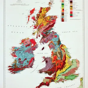
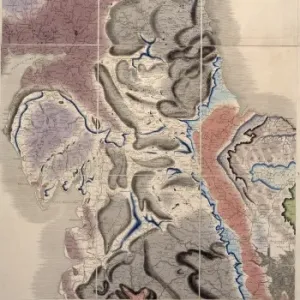
Antique Framed Print : Geological map of Britain and Ireland


![]()
Framed Photos from Mary Evans Picture Library
Geological map of Britain and Ireland
Fig 9 from Britain Before Man (1978), a Geological Museum publication
Mary Evans Picture Library makes available wonderful images created for people to enjoy over the centuries
Media ID 8613371
© Mary Evans Picture Library 2015 - https://copyrighthub.org/s0/hub1/creation/maryevans/MaryEvansPictureID/10706165
Before Geological Geology Great Britain United Kingdom
18"x18" (46x46cm) Antique Frame
Bevelled wood effect frame, card mounted, 12x12 archival quality photo print. Overall outside dimensions 18x18 inches (46x46cm). Environmentally and ozone friendly, Polycore® moulding has the look of real wood, is durable and light and easy to hang. Biodegradable and made with non-chlorinated gases (no toxic fumes) it is efficient; producing 100 tons of polystyrene can save 300 tons of trees! Prints are glazed with lightweight, shatterproof, optical clarity acrylic (providing the same general protection from the environment as glass). The back is stapled hardboard with a sawtooth hanger attached. Note: To minimise original artwork cropping, for optimum layout, and to ensure print is secure, the visible print may be marginally smaller
Bevelled Wood Effect Framed and Mounted Prints - Professionally Made and Ready to Hang
Estimated Image Size (if not cropped) is 29.4cm x 27.1cm (11.6" x 10.7")
Estimated Product Size is 46.5cm x 46.5cm (18.3" x 18.3")
These are individually made so all sizes are approximate
Artwork printed orientated as per the preview above, with landscape (horizontal) orientation to match the source image.
FEATURES IN THESE COLLECTIONS
> Europe
> Related Images
> Europe
> Republic of Ireland
> Maps
> Europe
> United Kingdom
> England
> London
> Sights
> British Museum
> Europe
> United Kingdom
> Related Images
> Maps and Charts
> Geological Map
> Maps and Charts
> Related Images
EDITORS COMMENTS
1. Title: "Geological Map of Britain and Ireland: A Snapshot of the Geological History of the British Isles" Fig. 9, from the prestigious publication "Britain Before Man" (1978) by the Geological Museum, offers a captivating glimpse into the geological makeup of Britain and Ireland. This exquisitely detailed geological map is a testament to the rich and complex history that lies beneath the surface of these two European nations. The intricate design of the map reveals the various rock types and formations that span millions of years, from the oldest Precambrian rocks to the youngest Quaternary deposits. The map's colorful key, located in the lower right corner, deciphers the different rock types, ranging from igneous and metamorphic to sedimentary formations. The British Isles' geological history is a fascinating tapestry of continental collisions, volcanic activity, and sedimentation processes. This map serves as an essential tool for geologists, archaeologists, and researchers, providing valuable insights into the geological events that have shaped the landscapes and cultures of Britain and Ireland. Moreover, the map offers a captivating visual representation of the Earth's history, revealing the intricate connections between geology and human history. The geological events depicted in the map have influenced the availability of natural resources, climate patterns, and the emergence of distinct ecosystems, all of which have played a crucial role in the development of human societies in the region. In summary, Fig. 9 from "Britain Before Man" is more than just a geological map; it is a visual narrative of the British Isles' geological history, a story that spans millions of years and continues to unfold. This stunning illustration is a must-see for anyone with an interest in geology, history, or the natural world.
MADE IN THE UK
Safe Shipping with 30 Day Money Back Guarantee
FREE PERSONALISATION*
We are proud to offer a range of customisation features including Personalised Captions, Color Filters and Picture Zoom Tools
SECURE PAYMENTS
We happily accept a wide range of payment options so you can pay for the things you need in the way that is most convenient for you
* Options may vary by product and licensing agreement. Zoomed Pictures can be adjusted in the Basket.