Antique Framed Print > Europe > United Kingdom > Scotland > Renfrewshire
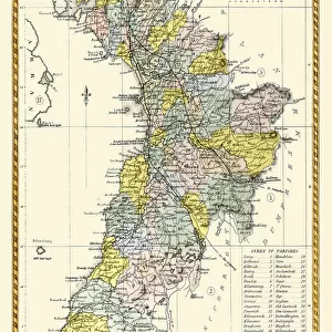
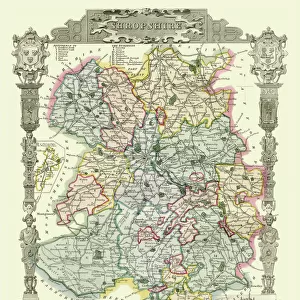
Antique Framed Print : Old Map of the County of Renfrew from the Philips Handy Atlas of 1882


![]()
Framed Photos from MapSeeker
Old Map of the County of Renfrew from the Philips Handy Atlas of 1882
PHA025
Welcome to the Mapseeker Image library and enter an historic gateway to one of the largest on-line collections of Historic Maps, Nostalgic Views, Vista's and Panorama's from a World gone by.
Media ID 20348207
County Map County Map Of Scotland Historic Map Old County Map Old Scottish County Map Scottish County Map Renfrew Renfrewshire
14"x12" (36x31cm) Antique Frame
Bevelled wood effect frame, card mounted, 10x8 archival quality photo print. Overall outside dimensions 14x12 inches (36x31cm). Environmentally and ozone friendly, the Polycore® moulding has the look of real wood, is durable and light and easy to hang. Biodegradable and made with non-chlorinated gases (no toxic fumes) it is efficient; producing 100 tons of polystyrene can save 300 tons of trees! Prints are glazed with lightweight, shatterproof, optical clarity acrylic (providing the same general protection from the environment as glass). The back is stapled hardboard with a sawtooth hanger attached. Note: To minimise original artwork cropping, for optimum layout, and to ensure print is secure, the visible print may be marginally smaller
Bevelled Wood Effect Framed and Mounted Prints - Professionally Made and Ready to Hang
Estimated Image Size (if not cropped) is 24.4cm x 19.5cm (9.6" x 7.7")
Estimated Product Size is 36.3cm x 31.2cm (14.3" x 12.3")
These are individually made so all sizes are approximate
Artwork printed orientated as per the preview above, with landscape (horizontal) orientation to match the source image.
FEATURES IN THESE COLLECTIONS
> Europe
> United Kingdom
> Scotland
> Maps
> Europe
> United Kingdom
> Scotland
> Renfrewshire
> Maps and Charts
> Early Maps
> Maps and Charts
> Related Images
> MapSeeker
> Maps from the British Isles
> Scotland and Counties PORTFOLIO
EDITORS COMMENTS
This print showcases an exquisite piece of history, the "Old Map of the County of Renfrew from the Philips Handy Atlas of 1882". Steeped in Scottish heritage, this vintage county map offers a fascinating glimpse into the past. With intricate details and delicate craftsmanship, this old Scottish county map takes us on a journey through time. It reveals the enchanting landscapes and charming towns that once graced Renfrewshire's borders. Each line represents more than just geographical boundaries; it tells stories of communities, traditions, and generations long gone. As we explore this historic Renfrew map, we can almost feel ourselves transported to another era. The faded hues and aged paper evoke a sense of nostalgia for simpler times when cartography was both artistry and science. Renfrewshire's rich history comes alive as we trace its rivers, roads, and landmarks etched onto this treasured document. From bustling cities to serene countryside vistas, every corner holds secrets waiting to be discovered. Whether you are a lover of maps or an avid historian seeking insight into Scotland's past, this old county map is sure to captivate your imagination. Its timeless beauty reminds us that beneath our modern world lies layers upon layers of stories waiting to be unveiled.
MADE IN THE UK
Safe Shipping with 30 Day Money Back Guarantee
FREE PERSONALISATION*
We are proud to offer a range of customisation features including Personalised Captions, Color Filters and Picture Zoom Tools
SECURE PAYMENTS
We happily accept a wide range of payment options so you can pay for the things you need in the way that is most convenient for you
* Options may vary by product and licensing agreement. Zoomed Pictures can be adjusted in the Basket.