Antique Framed Print > Europe > United Kingdom > Scotland > Maps
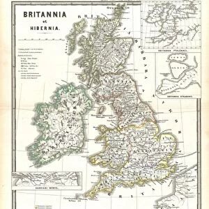
Antique Framed Print : 1801, Cary Map of Scotland, 4 Sheets, John Cary, 1754 - 1835, English cartographer


![]()
Framed Photos from Liszt Collection
1801, Cary Map of Scotland, 4 Sheets, John Cary, 1754 - 1835, English cartographer
Liszt Collection of nineteenth-century engravings and images to browse and enjoy
Media ID 14004884
© Artokoloro Quint Lox Limited
1754 1835 1754 – 1835 17541835 1801 English Cartographer John Cary Antique Map Latitude Longitude Mappa Mundi Old Antique Plan Old Antique View Ols Antique Map Rare Old Maps Topo
18"x16" (46x41cm) Antique Frame
Bevelled wood effect frame, card mounted, 12x10 archival quality photo print. Overall outside dimensions 18x16 inches (46x41cm). Environmentally and ozone friendly, the Polycore® moulding has the look of real wood, is durable and light and easy to hang. Biodegradable and made with non-chlorinated gases (no toxic fumes) it is efficient; producing 100 tons of polystyrene can save 300 tons of trees! Prints are glazed with lightweight, shatterproof, optical clarity acrylic (providing the same general protection from the environment as glass). The back is stapled hardboard with a sawtooth hanger attached. Note: To minimise original artwork cropping, for optimum layout, and to ensure print is secure, the visible print may be marginally smaller
Bevelled Wood Effect Framed and Mounted Prints - Professionally Made and Ready to Hang
Estimated Image Size (if not cropped) is 29.4cm x 26.6cm (11.6" x 10.5")
Estimated Product Size is 46.4cm x 41.4cm (18.3" x 16.3")
These are individually made so all sizes are approximate
Artwork printed orientated as per the preview above, with landscape (horizontal) orientation to match the source image.
FEATURES IN THESE COLLECTIONS
> Europe
> France
> Canton
> Landes
> Europe
> United Kingdom
> Scotland
> Maps
> Europe
> United Kingdom
> Scotland
> Posters
> Europe
> United Kingdom
> Scotland
> Related Images
> Historic
> Space exploration
> Maps and Charts
> Early Maps
> Maps and Charts
> Related Images
> Maps and Charts
> World
EDITORS COMMENTS
This print showcases the remarkable 1801 Cary Map of Scotland, meticulously crafted by the talented English cartographer John Cary. Consisting of four sheets, this exquisite piece of cartography artfully captures the topography and geography of Scotland during that era. The map is a testament to Cary's skill and attention to detail, as it beautifully illustrates the land with its intricate grid lines, latitude and longitude markings, and geometric precision. Its vintage charm transports us back in time to an ancient world where exploration and discovery were at their peak. As we gaze upon this historical artifact, we are reminded of the importance of maps in navigation and understanding our planet's diverse regions. The aged paper adds a touch of nostalgia while enhancing its historical significance. With its decorative elements and artistic flair, this rare old map serves as both an educational tool for studying Scotland's past and a stunning piece of artwork that can adorn any space. It invites us on a journey through time, allowing us to appreciate how far we have come in terms of geographic knowledge. Whether you are a history enthusiast or simply captivated by antique maps, this print from Liszt Collection is sure to be cherished for years to come.
MADE IN THE UK
Safe Shipping with 30 Day Money Back Guarantee
FREE PERSONALISATION*
We are proud to offer a range of customisation features including Personalised Captions, Color Filters and Picture Zoom Tools
SECURE PAYMENTS
We happily accept a wide range of payment options so you can pay for the things you need in the way that is most convenient for you
* Options may vary by product and licensing agreement. Zoomed Pictures can be adjusted in the Basket.