Antique Framed Print > Fine Art Storehouse > Map
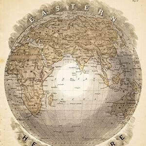
Antique Framed Print : Political Map of Asia


![]()
Framed Photos from Fine Art Storehouse
Political Map of Asia
Antique illustration of Political Map of Asia
Unleash your creativity and transform your space into a visual masterpiece!
Nastasic
Media ID 13590323
© This content is subject to copyright
Ancient Greece Ancient History Antiquities Asia Pac Chart Classical Greek Condition Empire Equipment European Culture Greco Roman Wrestling Greece Greek Culture Historical Geopolitical Location Iran Middle East Middle Eastern Culture Navigational Equipment Persian Culture Politics Politics And Government Serbia Styles Classical Style Drawing Art Product
14"x12" (36x31cm) Antique Frame
Bevelled wood effect frame, card mounted, 10x8 archival quality photo print. Overall outside dimensions 14x12 inches (36x31cm). Environmentally and ozone friendly, the Polycore® moulding has the look of real wood, is durable and light and easy to hang. Biodegradable and made with non-chlorinated gases (no toxic fumes) it is efficient; producing 100 tons of polystyrene can save 300 tons of trees! Prints are glazed with lightweight, shatterproof, optical clarity acrylic (providing the same general protection from the environment as glass). The back is stapled hardboard with a sawtooth hanger attached. Note: To minimise original artwork cropping, for optimum layout, and to ensure print is secure, the visible print may be marginally smaller
Bevelled Wood Effect Framed and Mounted Prints - Professionally Made and Ready to Hang
Estimated Image Size (if not cropped) is 24.4cm x 20.1cm (9.6" x 7.9")
Estimated Product Size is 36.3cm x 31.2cm (14.3" x 12.3")
These are individually made so all sizes are approximate
Artwork printed orientated as per the preview above, with landscape (horizontal) orientation to match the source image.
FEATURES IN THESE COLLECTIONS
> Fine Art Storehouse
> The Magical World of Illustration
> Nastasic Images & Illustrations
> Fine Art Storehouse
> Map
> Historical Maps
EDITORS COMMENTS
This print showcases an antique illustration of a Political Map of Asia, taking us on a journey to the past. With its classical Greek style and intricate engravings, this piece offers a glimpse into the historical geopolitical location of Asia, including regions such as Iran, Greece, Serbia, and the Middle East. The map's condition speaks volumes about ancient cultures and their political landscapes. It serves as a testament to the rich history that shaped our world today. The detailed depiction of navigational equipment reminds us of the importance placed on exploration during ancient times. Through this woodcut engraving, we are transported back in time to witness the grandeur of empires like Persia and experience European influences in Asian territories. This artwork not only highlights political boundaries but also sheds light on cultural exchanges between different civilizations. With no people present in this image, it allows us to focus solely on the artistry and craftsmanship behind this exquisite illustration technique. As we delve into each intricately drawn line and carefully etched detail, we gain insight into how cartography played a crucial role in politics and government throughout history. Nastasic's print is more than just an antiquity; it is a window into bygone eras where cultures intertwined through trade routes and greco-roman wrestling was celebrated. This remarkable piece invites viewers to appreciate both its aesthetic beauty and its profound historical significance.
MADE IN THE UK
Safe Shipping with 30 Day Money Back Guarantee
FREE PERSONALISATION*
We are proud to offer a range of customisation features including Personalised Captions, Color Filters and Picture Zoom Tools
SECURE PAYMENTS
We happily accept a wide range of payment options so you can pay for the things you need in the way that is most convenient for you
* Options may vary by product and licensing agreement. Zoomed Pictures can be adjusted in the Basket.