Antique Framed Print > Europe > United Kingdom > England > Maps
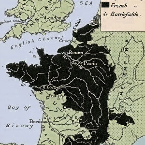
Antique Framed Print : Map Of The World Showing In Red The Extent Of The British Empire In 1901


![]()
Framed Photos from Design Pics
Map Of The World Showing In Red The Extent Of The British Empire In 1901
Design Pics offers Distinctively Different Imagery representing over 1,500 contributors
Media ID 18181503
© Ken Welsh / Design Pics
Britain Cartography Chart Empire Imperial World Imperialism
14"x12" (36x31cm) Antique Frame
Bevelled wood effect frame, card mounted, 10x8 archival quality photo print. Overall outside dimensions 14x12 inches (36x31cm). Environmentally and ozone friendly, the Polycore® moulding has the look of real wood, is durable and light and easy to hang. Biodegradable and made with non-chlorinated gases (no toxic fumes) it is efficient; producing 100 tons of polystyrene can save 300 tons of trees! Prints are glazed with lightweight, shatterproof, optical clarity acrylic (providing the same general protection from the environment as glass). The back is stapled hardboard with a sawtooth hanger attached. Note: To minimise original artwork cropping, for optimum layout, and to ensure print is secure, the visible print may be marginally smaller
Bevelled Wood Effect Framed and Mounted Prints - Professionally Made and Ready to Hang
Estimated Image Size (if not cropped) is 24.4cm x 19.2cm (9.6" x 7.6")
Estimated Product Size is 36.3cm x 31.2cm (14.3" x 12.3")
These are individually made so all sizes are approximate
Artwork printed orientated as per the preview above, with landscape (horizontal) orientation to match the source image.
FEATURES IN THESE COLLECTIONS
> Europe
> United Kingdom
> England
> Maps
> Maps and Charts
> British Empire Maps
> Maps and Charts
> Early Maps
> Maps and Charts
> Related Images
> Maps and Charts
> World
EDITORS COMMENTS
This photo print, titled "Map Of The World Showing In Red The Extent Of The British Empire In 1901" takes us on a journey back in time to the height of British imperialism. Created by the talented Ken Welsh, this historical cartography masterpiece showcases the vastness and influence of the British Empire during its peak in 1901. With meticulous attention to detail, Welsh expertly captures every inch of this horizontal map, which spans across continents and oceans. The vibrant red color highlights the territories under British rule, showcasing their imperial dominance over a significant portion of the world. As we gaze upon this remarkable piece of art, we are transported to an era where England's power extended far beyond its borders. It serves as a visual reminder of Britain's historical impact on global politics and trade. The Map Of The World Showing In Red The Extent Of The British Empire In 1901 is not just a mere chart; it represents an era defined by exploration, conquests, and cultural exchange. It invites us to reflect upon history while appreciating the craftsmanship behind such intricate cartographic work. Whether you are a history enthusiast or simply captivated by beautiful design, this print is sure to spark curiosity and ignite conversations about one of history's most influential empires – Great Britain.
MADE IN THE UK
Safe Shipping with 30 Day Money Back Guarantee
FREE PERSONALISATION*
We are proud to offer a range of customisation features including Personalised Captions, Color Filters and Picture Zoom Tools
SECURE PAYMENTS
We happily accept a wide range of payment options so you can pay for the things you need in the way that is most convenient for you
* Options may vary by product and licensing agreement. Zoomed Pictures can be adjusted in the Basket.