Acrylic Blox > Europe > United Kingdom > England > Essex > Mountnessing
Acrylic Blox : MA Essex Topsfield Vector Road Map


![]()
Mounted Prints from Fine Art Storehouse
MA Essex Topsfield Vector Road Map
MA Essex Topsfield Vector Road Map. All source data is in the public domain. U.S. Census Bureau Census Tiger. Used Layers: areawater, linearwater, roads, rails, cousub, pointlm, uac10
Unleash your creativity and transform your space into a visual masterpiece!
Frank Ramspott
Media ID 20689441
© Frank Ramspott, all rights reserved
City Map Computer Graphic County Digital Composite District Essex Geographical Border Massachusetts Road Map Text Vector Boxford Digitally Generated Image Wenham
8"x6" (20x15cm) Acrylic Blox
Your photographic print is held in place by magnets and a micro thin sheet of metal covering the back of a 20mm piece of clear acrylic. Your print is held in place with magnets so can easily be replaced if needed.
Streamlined, one sided modern and attractive table top print
Estimated Product Size is 15.2cm x 20.3cm (6" x 8")
These are individually made so all sizes are approximate
Artwork printed orientated as per the preview above, with portrait (vertical) orientation to match the source image.
FEATURES IN THESE COLLECTIONS
> Animals
> Mammals
> Cats (Wild)
> Tiger
> Arts
> Contemporary art
> Digital artwork
> Street art
> Arts
> Street art graffiti
> Digital art
> Digital paintings
> Europe
> United Kingdom
> England
> Essex
> Mountnessing
> Europe
> United Kingdom
> England
> Essex
> Related Images
> Maps and Charts
> Related Images
> Popular Themes
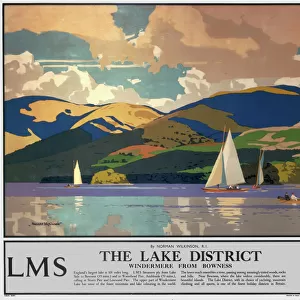
> Lake District
EDITORS COMMENTS
This print showcases the intricately detailed MA Essex Topsfield Vector Road Map. With all source data in the public domain, this map is a true representation of the area's geography and infrastructure. Created using various layers including areawater, linearwater, roads, rails, cousub, pointlm, and uac10 from U. S. Census Bureau Census Tiger database. The design of this digitally generated image is a testament to meticulous cartography skills. The absence of people allows us to focus solely on the beauty and functionality of this colorful vector map. Every geographical feature has been carefully rendered with precision and accuracy. From bustling cities to serene towns nestled by rivers and lakes, every location within Essex County comes alive through this stunning composition. Pingrees Hill stands tall while Mount Eleanor adds depth to the landscape. Boxford reveals its charm as Salem Beverly Reservoir glistens nearby. Wenham emerges as a vibrant hub connecting various routes that intertwine throughout the region. The text elegantly labels each street and road for easy navigation across Topsfield's diverse terrain. With its digital composite format seamlessly merging different elements together, this visually striking artwork captures both physical geography and urban planning in one frame. Frank Ramspott's expertise shines through in his creation of this remarkable map print - an exquisite blend of artistry and functionality that will surely captivate any admirer of cartographic masterpieces.
MADE IN THE UK
Safe Shipping with 30 Day Money Back Guarantee
FREE PERSONALISATION*
We are proud to offer a range of customisation features including Personalised Captions, Color Filters and Picture Zoom Tools
SECURE PAYMENTS
We happily accept a wide range of payment options so you can pay for the things you need in the way that is most convenient for you
* Options may vary by product and licensing agreement. Zoomed Pictures can be adjusted in the Basket.