Acrylic Blox > Europe > United Kingdom > Scotland > Edinburgh > Edinburgh
Acrylic Blox : Commercial highways of the world (colour litho)
")
")


![]()
Mounted Prints from Fine Art Finder
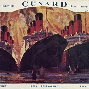
Commercial highways of the world (colour litho)
3648590 Commercial highways of the world (colour litho) by English School, (20th century); Private Collection; (add.info.: Commercial highways of the world. Illustration for Atlas of the Worlds Commerce compiled from the latest official returns at the Edinburgh Geographical Institute and edited by J G Bartholomew (George Newnes, c 1907).); © Look and Learn
Media ID 23146706
© Look and Learn / Bridgeman Images
Chart Charts Commercial Countries Economics Economies Economy Global Highways International Land Mercantile Principal Steamships
8"x6" (20x15cm) Acrylic Blox
Your photographic print is held in place by magnets and a micro thin sheet of metal covering the back of a 20mm piece of clear acrylic. Your print is held in place with magnets so can easily be replaced if needed.
Streamlined, one sided modern and attractive table top print
Estimated Product Size is 20.3cm x 15.2cm (8" x 6")
These are individually made so all sizes are approximate
Artwork printed orientated as per the preview above, with landscape (horizontal) orientation to match the source image.
FEATURES IN THESE COLLECTIONS
> Europe
> France
> Canton
> Landes
> Europe
> United Kingdom
> Scotland
> Edinburgh
> Edinburgh
> Europe
> United Kingdom
> Scotland
> Lothian
> Edinburgh
> Maps and Charts
> Related Images
> Maps and Charts
> World
> Fine Art Finder
> Artists
> English School
EDITORS COMMENTS
This print titled "Commercial Highways of the World" takes us back in time to the early 20th century when global trade and commerce were flourishing. The vibrant colors of this lithograph bring to life a map that showcases the principal countries and their economic connections through land and sea. As we gaze upon this historic chart, we are reminded of the significant role played by ships, sailing vessels, and steamships in shaping international economies. Each intricate detail on this map represents a vital link in the chain of global trade routes that spanned across continents. The Atlas of the World's Commerce, from which this illustration is derived, was compiled with meticulous precision using official data from the renowned Edinburgh Geographical Institute. It serves as a testament to human ingenuity and resourcefulness in mapping out commercial highways that connected nations far and wide. In an era before modern technology transformed our world into a digital landscape, maps like these held immense value for merchants, explorers, and scholars alike. They provided invaluable insights into marine navigation, facilitating prosperous trade relationships between nations. This remarkable print captures not only history but also evokes curiosity about how our present-day economy has evolved since then. It stands as a reminder of our interconnectedness as citizens of a globalized world where commerce continues to shape our lives.
MADE IN THE UK
Safe Shipping with 30 Day Money Back Guarantee
FREE PERSONALISATION*
We are proud to offer a range of customisation features including Personalised Captions, Color Filters and Picture Zoom Tools
SECURE PAYMENTS
We happily accept a wide range of payment options so you can pay for the things you need in the way that is most convenient for you
* Options may vary by product and licensing agreement. Zoomed Pictures can be adjusted in the Basket.