Home > Europe > France > Canton > Bas Rhin
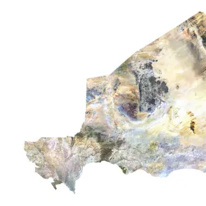
Departement of Pyrenees-Atlantiques, France, Relief Map

![]()
Wall Art and Photo Gifts from Universal Images Group (UIG)
Departement of Pyrenees-Atlantiques, France, Relief Map
Relief map of the departement of Pyrenees-Atlantiques in Aquitaine, France. The southern part, along the border with Spain, is located in the Pyrenees mountain range. This image was processed from elevation data
Universal Images Group (UIG) manages distribution for many leading specialist agencies worldwide
Media ID 9608555
© Planet Observer
Alsace Bas Rhin Geographical Border Relief Map Satellite View
FEATURES IN THESE COLLECTIONS
> Europe
> France
> Canton
> Bas Rhin
> Europe
> France
> Canton
> Pyrenees
> Europe
> France
> Canton
> Rhin
> Universal Images Group (UIG)
> Universal Images Group
> Satellite and Aerial
> Planet Observer 6
EDITORS COMMENTS
This stunning print captures the breathtaking beauty of the Departement of Pyrenees-Atlantiques in Aquitaine, France. The relief map showcases the diverse topography and physical geography of this region, which is located along the border with Spain in the majestic Pyrenees mountain range. The image, processed from elevation data, provides a detailed view of the landscape's contours and features. From towering peaks to deep valleys, every inch of this area is depicted with precision and accuracy. The vibrant colors used in this cartographic representation add depth and dimension to the map. As we explore this photograph further, it becomes evident that no people are present in this scene. Instead, nature takes center stage as it unfolds its wonders across Bas Rhin. This satellite view allows us to appreciate how geographical borders seamlessly blend into one another within Europe. Whether you are an avid hiker or simply a lover of natural beauty, this vertical print will transport you to the heart of Pyrenees-Atlantiques. It serves as a reminder that our planet holds countless hidden gems waiting to be discovered and cherished
MADE IN THE UK
Safe Shipping with 30 Day Money Back Guarantee
FREE PERSONALISATION*
We are proud to offer a range of customisation features including Personalised Captions, Color Filters and Picture Zoom Tools
SECURE PAYMENTS
We happily accept a wide range of payment options so you can pay for the things you need in the way that is most convenient for you
* Options may vary by product and licensing agreement. Zoomed Pictures can be adjusted in the Basket.