Home > North America > United States of America > Massachusetts > Boston
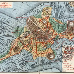
1807 Buache Map Of Boston Massachusetts Topography

![]()
Wall Art and Photo Gifts from Universal Images Group (UIG)
1807 Buache Map Of Boston Massachusetts Topography
1807, Buache Map of Boston, Massachusetts
Universal Images Group (UIG) manages distribution for many leading specialist agencies worldwide
Media ID 38548379
© Artokoloro Quint Lox Limited
1807 Massachusetts Antique Map Latitude Longitude Mappa Mundi Old Antique Plan Old Antique View Ols Antique Map Rare Old Maps Topo
FEATURES IN THESE COLLECTIONS
> Europe
> France
> Canton
> Landes
> Historic
> Space exploration
> Maps and Charts
> Early Maps
> Maps and Charts
> Related Images
> Maps and Charts
> World
> North America
> United States of America
> Massachusetts
> Boston
> Universal Images Group (UIG)
> History
> Historical Maps
EDITORS COMMENTS
Step back in time to 1807 with this stunning print of the Buache Map of Boston, Massachusetts. This intricate illustration provides a fascinating glimpse into the topography of Boston during the early 19th century. Created by French cartographer Philippe Buache, this map showcases the city's layout, landmarks, and geographical features with remarkable detail.
The map is a testament to the artistry and skill of cartography during this era. The delicate lines and subtle shading bring forth a sense of depth and dimensionality, making it easy to imagine life in Boston during this period. From the winding streets to the bustling harbor, every aspect of the city is meticulously rendered.
This vintage map is not only a beautiful piece of art but also a valuable historical resource for anyone interested in geography, travel, or American history. It serves as a reminder of how far we've come since then and how much our understanding of mapping has evolved over time.
Printed on high-quality paper, this reproduction captures all the intricate details and textures of the original map. Hang it proudly in your home or office as a unique conversation starter that will transport you back in time.
MADE IN THE UK
Safe Shipping with 30 Day Money Back Guarantee
FREE PERSONALISATION*
We are proud to offer a range of customisation features including Personalised Captions, Color Filters and Picture Zoom Tools
SECURE PAYMENTS
We happily accept a wide range of payment options so you can pay for the things you need in the way that is most convenient for you
* Options may vary by product and licensing agreement. Zoomed Pictures can be adjusted in the Basket.