Home > Asia > Iran > Lakes > Caspian Sea
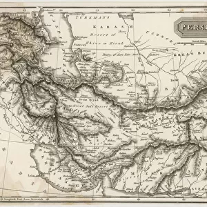
The Middle East: Iraq, Iran, Black Sea and Caspian Sea, detail from a planisphere, engraving, 1457

![]()
Wall Art and Photo Gifts from Universal Images Group (UIG)
The Middle East: Iraq, Iran, Black Sea and Caspian Sea, detail from a planisphere, engraving, 1457
Cartography, 15th century. The Middle East: Iraq, Iran, Black Sea and Caspian Sea, detail from a planisphere, 1457. Engraving
Universal Images Group (UIG) manages distribution for many leading specialist agencies worldwide
Media ID 9571083
© DEA PICTURE LIBRARY
15th Century Black Sea Caspian Sea Iran Iraq River
FEATURES IN THESE COLLECTIONS
> Architecture
> Related Images
> Arts
> Landscape paintings
> Waterfall and river artworks
> River artworks
> Asia
> Iran
> Lakes
> Caspian Sea
> Universal Images Group (UIG)
> Art
> Painting, Sculpture & Prints
> Cartography
EDITORS COMMENTS
This print takes us back in time to the 15th century, where cartography was still a burgeoning field. The intricate engraving showcases a detailed planisphere of the Middle East, specifically highlighting Iraq, Iran, the Black Sea, and the Caspian Sea. The craftsmanship of this antique piece is truly remarkable. Every line and curve has been meticulously etched onto the surface, capturing not only geographical accuracy but also an artistic flair. The horizontal composition allows for a comprehensive view of these significant regions. As we delve into this historical map, we are transported to an era when exploration and discovery were at their peak. It serves as a testament to human curiosity and our relentless pursuit of knowledge about our world. The inclusion of architectural elements adds depth and context to the image. We can observe various structures that dot the landscape along riversides – perhaps representing ancient cities or landmarks that held great significance during that period. What makes this print even more intriguing is its absence of human representation; it allows us to focus solely on the geography itself without any distractions. This creates an opportunity for viewers to immerse themselves in this rich tapestry of landforms and water bodies. Overall, this engraving from 1457 is not just a mere map but rather a work of art that encapsulates both scientific precision and aesthetic beauty—a true treasure from centuries past.
MADE IN THE UK
Safe Shipping with 30 Day Money Back Guarantee
FREE PERSONALISATION*
We are proud to offer a range of customisation features including Personalised Captions, Color Filters and Picture Zoom Tools
SECURE PAYMENTS
We happily accept a wide range of payment options so you can pay for the things you need in the way that is most convenient for you
* Options may vary by product and licensing agreement. Zoomed Pictures can be adjusted in the Basket.