Tote Bag > Maps and Charts > Related Images
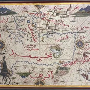
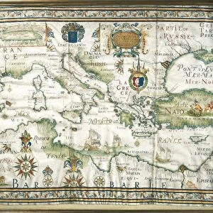
Tote Bag : Map of Mediterranean Sea by Francois Ollive, Marseille, 1664


![]()
Home Decor from Universal Images Group (UIG)
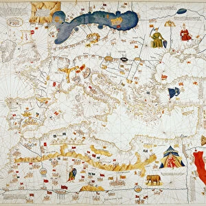
Map of Mediterranean Sea by Francois Ollive, Marseille, 1664
Cartography, 17th century. Map of the Mediterranean Sea by Francois Ollive, Marseille, 1664
Universal Images Group (UIG) manages distribution for many leading specialist agencies worldwide
Media ID 9505691
© DEA / M. SEEMULLER
17th Century Coastline Coat Of Arms Mediterranean Sea Western Script
Canvas Tote Bag
Our tote bags are made from soft, durable, poly-poplin fabric and include a one inch (2.5cm) black strap for easy carrying on your shoulder. All seams are double-stitched for added durability. Each tote bag is machine-washable in cold water and is printed on both sides using the same image. Approximate size of bag is 50x33cm (20"x13")
Our tote bags are made from soft durable fabric and include a strap for easy carrying
Estimated Product Size is 50cm x 32.7cm (19.7" x 12.9")
These are individually made so all sizes are approximate
FEATURES IN THESE COLLECTIONS
> Maps and Charts
> Related Images
> Universal Images Group (UIG)
> Art
> Painting, Sculpture & Prints
> Cartography
EDITORS COMMENTS
This print showcases a remarkable piece of cartography from the 17th century - the "Map of Mediterranean Sea" by Francois Ollive, Marseille, 1664. With its full-length depiction and intricate details, this map takes us on a journey back in time to explore the rich history and physical geography of the Mediterranean region. The artist's skillful use of Western script beautifully labels various coastlines along the Mediterranean Sea, allowing us to trace ancient trade routes and envision bustling ports that once thrived centuries ago. The inclusion of coat of arms adds an air of grandeur and authenticity to this studio shot. As we delve into this artfully crafted illustration, we are reminded of the importance cartography held during this era as a means for navigation and exploration. This map serves not only as a historical artifact but also as a testament to human curiosity about our world. Without any people present in the image, it allows us to focus solely on appreciating Ollive's meticulous attention to detail and his ability to capture both artistic beauty and scientific accuracy. This horizontal composition invites us to immerse ourselves in every nook and cranny depicted on this map. Through this print from Universal Images Group (UIG), we can marvel at how artistry meets science in cartography while reflecting upon our past journeys across these storied waters.
MADE IN THE UK
Safe Shipping with 30 Day Money Back Guarantee
FREE PERSONALISATION*
We are proud to offer a range of customisation features including Personalised Captions, Color Filters and Picture Zoom Tools
SECURE PAYMENTS
We happily accept a wide range of payment options so you can pay for the things you need in the way that is most convenient for you
* Options may vary by product and licensing agreement. Zoomed Pictures can be adjusted in the Basket.