Framed Print > Maps and Charts > Related Images
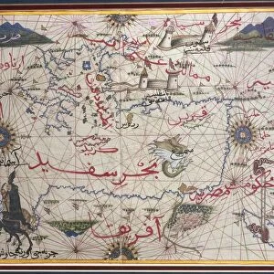
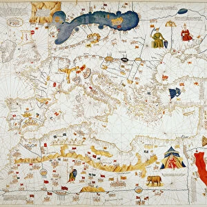
Framed Print : Map of Mediterranean Sea by Francois Ollive, Marseille, 1664


![]()
Framed Photos from Universal Images Group (UIG)
Map of Mediterranean Sea by Francois Ollive, Marseille, 1664
Cartography, 17th century. Map of the Mediterranean Sea by Francois Ollive, Marseille, 1664
Universal Images Group (UIG) manages distribution for many leading specialist agencies worldwide
Media ID 9505691
© DEA / M. SEEMULLER
17th Century Coastline Coat Of Arms Mediterranean Sea Western Script
14"x12" (38x32cm) Modern Frame
Discover the rich history of cartography with our exquisite Framed Prints from Media Storehouse. This stunning offering features a rare and intriguing Map of the Mediterranean Sea by Francois Ollive of Marseille, dated 1664. Drawn in the 17th century, this captivating map showcases the detailed exploration of the Mediterranean during an era of significant maritime discovery. Add an air of sophistication and historical depth to any room with this elegant and authentic framed print from Universal Images Group. Experience the past like never before.
Wood effect frame, card mounted, 10x8 archival quality photo print. Overall outside dimensions 14x12 inches (38x32cm). Environmentally and ozone friendly, 40mm wide x 15mm Polycore® moulding has the look of real wood, is durable and light and easy to hang. Biodegradable and made with non-chlorinated gases (no toxic fumes) it is efficient; producing 100 tons of polystyrene can save 300 tons of trees! Prints are glazed with lightweight, shatterproof, optical clarity acrylic (providing the same general protection from the environment as glass). The back is stapled hardboard with a sawtooth hanger attached. Note: To minimise original artwork cropping, for optimum layout, and to ensure print is secure, the visible print may be marginally smaller
Contemporary Framed and Mounted Prints - Professionally Made and Ready to Hang
Estimated Image Size (if not cropped) is 24.4cm x 17.1cm (9.6" x 6.7")
Estimated Product Size is 37.6cm x 32.5cm (14.8" x 12.8")
These are individually made so all sizes are approximate
Artwork printed orientated as per the preview above, with landscape (horizontal) orientation to match the source image.
FEATURES IN THESE COLLECTIONS
> Maps and Charts
> Related Images
> Universal Images Group (UIG)
> Art
> Painting, Sculpture & Prints
> Cartography
EDITORS COMMENTS
This print showcases a remarkable piece of cartography from the 17th century - the "Map of Mediterranean Sea" by Francois Ollive, Marseille, 1664. With its full-length depiction and intricate details, this map takes us on a journey back in time to explore the rich history and physical geography of the Mediterranean region. The artist's skillful use of Western script beautifully labels various coastlines along the Mediterranean Sea, allowing us to trace ancient trade routes and envision bustling ports that once thrived centuries ago. The inclusion of coat of arms adds an air of grandeur and authenticity to this studio shot. As we delve into this artfully crafted illustration, we are reminded of the importance cartography held during this era as a means for navigation and exploration. This map serves not only as a historical artifact but also as a testament to human curiosity about our world. Without any people present in the image, it allows us to focus solely on appreciating Ollive's meticulous attention to detail and his ability to capture both artistic beauty and scientific accuracy. This horizontal composition invites us to immerse ourselves in every nook and cranny depicted on this map. Through this print from Universal Images Group (UIG), we can marvel at how artistry meets science in cartography while reflecting upon our past journeys across these storied waters.
MADE IN THE UK
Safe Shipping with 30 Day Money Back Guarantee
FREE PERSONALISATION*
We are proud to offer a range of customisation features including Personalised Captions, Color Filters and Picture Zoom Tools
SECURE PAYMENTS
We happily accept a wide range of payment options so you can pay for the things you need in the way that is most convenient for you
* Options may vary by product and licensing agreement. Zoomed Pictures can be adjusted in the Basket.