Tote Bag > Europe > France > Lakes > Related Images
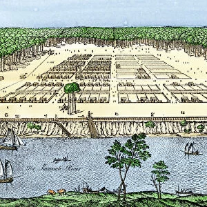
Tote Bag : French map of the Great Lakes, 1703


![]()
Home Decor from North Wind
French map of the Great Lakes, 1703
La Hontans map of the Great Lakes and Saint Lawrence valley, 1703.
Hand-colored 19th-century woodcut reproduction of an 18th century illustration
North Wind Picture Archives brings history to life with stock images and hand-colored illustrations
Media ID 5880924
© North Wind Picture Archives
1700s 18th Century Aboriginal America Amerindian Boston Canada Canadian Colonial Colony Discover Document East Eastern English Colony Exploration Explore French French Canada French Colony Great Lakes Indian Iroquois Lake Erie Lake Michigan Lake Ontario Lake Superior Montreal Native Native American New England New France New World New York Quebec Settlement 1703 Lake Huron Trois Rivieres
Canvas Tote Bag
Our tote bags are made from soft, durable, poly-poplin fabric and include a one inch (2.5cm) black strap for easy carrying on your shoulder. All seams are double-stitched for added durability. Each tote bag is machine-washable in cold water and is printed on both sides using the same image. Approximate size of bag is 50x33cm (20"x13")
Our tote bags are made from soft durable fabric and include a strap for easy carrying
Estimated Product Size is 50cm x 32.7cm (19.7" x 12.9")
These are individually made so all sizes are approximate
FEATURES IN THESE COLLECTIONS
> North Wind Picture Archives
> Exploration
> North Wind Picture Archives
> Maps
> Europe
> France
> Lakes
> Related Images
> Europe
> United Kingdom
> England
> Lakes
> Europe
> United Kingdom
> England
> Maps
> Europe
> United Kingdom
> England
> York
> Historic
> Colonial America illustrations
> 18th century America
> Historic
> Colonial America illustrations
> Colonial America
> Historic
> Colonial America illustrations
> Historic
> Colonial history
> Colonial art and artists
EDITORS COMMENTS
This vintage print showcases a remarkable piece of history - the French map of the Great Lakes from 1703. Crafted by La Hontans, this hand-colored woodcut reproduction provides us with a glimpse into the exploration and colonial era of North America. The intricately detailed illustration takes us back to the 18th century, when European powers were vying for control over vast territories in the New World. The map highlights key locations such as New York, Boston, Montreal, Quebec, and Trois-Rivieres, shedding light on their significance during that time. As we delve deeper into this artwork's narrative, we are reminded of the rich heritage and traditions of both Native American tribes and early settlers in these regions. The Iroquois people played a vital role in shaping this landscape alongside French colonizers who established settlements throughout New France. With Lake Ontario, Lake Erie, Lake Michigan, Lake Superior, and Lake Huron prominently displayed on the map's canvas-like backdrop; it serves as a testament to the importance of these waterways for trade routes and transportation during that period. This historical document not only captures an essential chapter in Canadian and American history but also serves as a visual representation of cultural exchange between Amerindian communities and European explorers. It stands as an enduring symbol of discovery that continues to fascinate scholars today.
MADE IN THE UK
Safe Shipping with 30 Day Money Back Guarantee
FREE PERSONALISATION*
We are proud to offer a range of customisation features including Personalised Captions, Color Filters and Picture Zoom Tools
SECURE PAYMENTS
We happily accept a wide range of payment options so you can pay for the things you need in the way that is most convenient for you
* Options may vary by product and licensing agreement. Zoomed Pictures can be adjusted in the Basket.