Tote Bag > Maps and Charts > Related Images
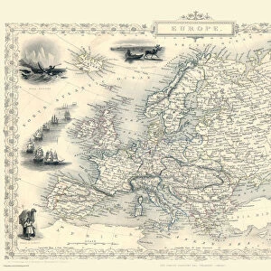
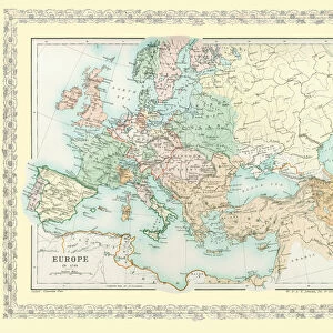
Tote Bag : Map of Europe showing how it appeared at the time of the Third Crusade AD 1190


![]()
Home Decor from MapSeeker
Map of Europe showing how it appeared at the time of the Third Crusade AD 1190
EHIST006
Welcome to the Mapseeker Image library and enter an historic gateway to one of the largest on-line collections of Historic Maps, Nostalgic Views, Vista's and Panorama's from a World gone by.
Media ID 20348274
Europe Europe Map Map Of Europe
Canvas Tote Bag
Our tote bags are made from soft, durable, poly-poplin fabric and include a one inch (2.5cm) black strap for easy carrying on your shoulder. All seams are double-stitched for added durability. Each tote bag is machine-washable in cold water and is printed on both sides using the same image. Approximate size of bag is 50x33cm (20"x13")
Our tote bags are made from soft durable fabric and include a strap for easy carrying
Estimated Product Size is 50cm x 32.7cm (19.7" x 12.9")
These are individually made so all sizes are approximate
FEATURES IN THESE COLLECTIONS
> MapSeeker
> Maps of Europe
> Old Maps of Europe and Small Islands of
> Maps and Charts
> Related Images
EDITORS COMMENTS
This print showcases a historically significant artifact - the Map of Europe during the Third Crusade in AD 1190. A visual representation of an era filled with fervent religious zeal and political turmoil, this map offers a glimpse into the complex dynamics that shaped medieval Europe. As we gaze upon this ancient cartographic masterpiece, our eyes are drawn to the intricate details meticulously etched onto its surface. The boundaries of kingdoms and empires come alive, revealing a patchwork of territories governed by various rulers. From England's green pastures to Byzantium's opulent splendor, every corner of Europe is vividly portrayed. The map serves as a testament to the profound impact of the Third Crusade on European history. It highlights key cities such as Jerusalem, Acre, and Constantinople - pivotal locations where Christian forces clashed with their Muslim counterparts in fierce battles for control over holy lands. Beyond its historical significance, this print also captivates us with its artistic charm. The delicate calligraphy adorning each label and border reflects the craftsmanship prevalent during that time period. The vibrant colors used to depict rivers, mountains, and seas transport us back in time. Whether you are an avid history enthusiast or simply intrigued by maps' ability to tell stories from centuries ago, this stunning print effortlessly transports you into an era defined by faith-driven quests for power and glory.
MADE IN THE UK
Safe Shipping with 30 Day Money Back Guarantee
FREE PERSONALISATION*
We are proud to offer a range of customisation features including Personalised Captions, Color Filters and Picture Zoom Tools
SECURE PAYMENTS
We happily accept a wide range of payment options so you can pay for the things you need in the way that is most convenient for you
* Options may vary by product and licensing agreement. Zoomed Pictures can be adjusted in the Basket.