Tote Bag > Europe > United Kingdom > England > London > Towns > Welling
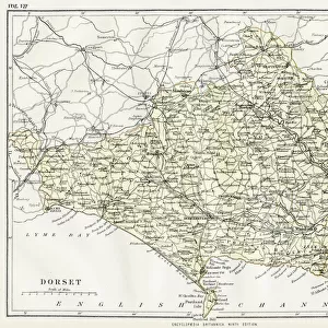
Tote Bag : Old County Map of Dorsetshire 1836 by Thomas Moule


![]()
Home Decor from MapSeeker
Old County Map of Dorsetshire 1836 by Thomas Moule
This is a fine decorative reproduction County Map of Dorsetshire from the First Edition series of Thomas Moule Maps, originally Published in 1836. The well-known series of County Maps which are known as Moules feature beautiful vignette views and were first published in separate sections for each county in 1830-32, they were then published in collected form in a two-volume work: The English Counties Delineated: or a Topographical Description of England: Illustrated by a Complete Series of County Maps by Thomas Moule: London: Published by George Virtue 1836
Welcome to the Mapseeker Image library and enter an historic gateway to one of the largest on-line collections of Historic Maps, Nostalgic Views, Vista's and Panorama's from a World gone by.
Media ID 20348072
© Mapseeker Publishing Ltd
County Map County Map Of England English County Map Historic Map Moule Map Old County Map Old English County Map Old Moule Map Thomas Moule Thomas Moule Map Dorsetshire
Canvas Tote Bag
Our tote bags are made from soft, durable, poly-poplin fabric and include a one inch (2.5cm) black strap for easy carrying on your shoulder. All seams are double-stitched for added durability. Each tote bag is machine-washable in cold water and is printed on both sides using the same image. Approximate size of bag is 50x33cm (20"x13")
Our tote bags are made from soft durable fabric and include a strap for easy carrying
Estimated Product Size is 50cm x 32.7cm (19.7" x 12.9")
These are individually made so all sizes are approximate
FEATURES IN THESE COLLECTIONS
> MapSeeker
> Maps from the British Isles
> England and Counties PORTFOLIO
> Arts
> Artists
> M
> Thomas Moule
> Europe
> United Kingdom
> England
> Dorset
> Related Images
> Europe
> United Kingdom
> England
> London
> Towns
> Welling
> Europe
> United Kingdom
> England
> Maps
> Europe
> United Kingdom
> England
> Wells
> Maps and Charts
> Early Maps
> Maps and Charts
> Related Images
EDITORS COMMENTS
This exquisite print showcases the "Old County Map of Dorsetshire 1836" by Thomas Moule, a renowned cartographer from the early 19th century. Originally published as part of Moule's First Edition series in 1836, this decorative reproduction captures the charm and historical significance of Dorsetshire. Moule's County Maps are highly regarded for their intricate details and captivating vignette views. Each county was meticulously depicted in separate sections between 1830-32 before being compiled into a two-volume work titled "The English Counties Delineated: or a Topographical Description of England". This particular map was published by George Virtue in London in 1836. As you explore this historic map, you will be transported back to a time when Dorsetshire thrived with its unique landscapes and bustling communities. The careful craftsmanship employed by Moule allows us to appreciate not only the geographical features but also gain insights into the cultural heritage of this region. Whether you have an affinity for old maps, an interest in British history, or simply admire fine artistry, this print is sure to captivate your imagination. It serves as both a testament to Thomas Moule's skill as a cartographer and as a window into the rich past of Dorsetshire.
MADE IN THE UK
Safe Shipping with 30 Day Money Back Guarantee
FREE PERSONALISATION*
We are proud to offer a range of customisation features including Personalised Captions, Color Filters and Picture Zoom Tools
SECURE PAYMENTS
We happily accept a wide range of payment options so you can pay for the things you need in the way that is most convenient for you
* Options may vary by product and licensing agreement. Zoomed Pictures can be adjusted in the Basket.