Tote Bag > Arts > Contemporary art > Digital artwork > Street art
Tote Bag : MA Norfolk Foxborough Vector Road Map


![]()
Home Decor from Fine Art Storehouse
MA Norfolk Foxborough Vector Road Map
MA Norfolk Foxborough Vector Road Map. All source data is in the public domain. U.S. Census Bureau Census Tiger. Used Layers: areawater, linearwater, roads, rails, cousub, pointlm, uac10
Unleash your creativity and transform your space into a visual masterpiece!
Frank Ramspott
Media ID 20692593
© Frank Ramspott, all rights reserved
City Map Computer Graphic County Digital Composite District Geographical Border Massachusetts Norfolk Road Map Text Vector Digitally Generated Image Mansfield
Canvas Tote Bag
Our tote bags are made from soft, durable, poly-poplin fabric and include a one inch (2.5cm) black strap for easy carrying on your shoulder. All seams are double-stitched for added durability. Each tote bag is machine-washable in cold water and is printed on both sides using the same image. Approximate size of bag is 50x33cm (20"x13")
Our tote bags are made from soft durable fabric and include a strap for easy carrying
Estimated Product Size is 32.7cm x 50cm (12.9" x 19.7")
These are individually made so all sizes are approximate
FEATURES IN THESE COLLECTIONS
> Fine Art Storehouse
> Map
> Reference Maps
> Animals
> Mammals
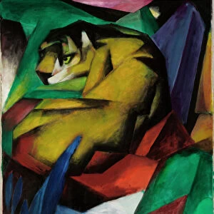
> Cats (Wild)
> Tiger
> Animals
> Mammals
> Muridae
> Water Mouse
> Arts
> Contemporary art
> Digital artwork
> Street art
> Arts
> Landscape paintings
> Waterfall and river artworks
> River artworks
> Arts
> Portraits
> Pop art gallery
> Street art portraits
> Arts
> Street art graffiti
> Digital art
> Digital paintings
> Europe
> United Kingdom
> England
> Norfolk
> Related Images
> Maps and Charts
> Related Images
> Popular Themes
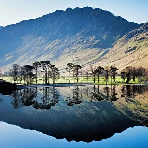
> Lake District
EDITORS COMMENTS
This print showcases the intricate details of the MA Norfolk Foxborough Vector Road Map. Created by talented cartographer Frank Ramspott, this digitally generated image is a true masterpiece of design and precision. Using various layers sourced from the public domain, including data from the U. S. Census Bureau Census Tiger, Ramspott has expertly crafted a visually stunning representation of Massachusetts' Norfolk County district. The map includes essential elements such as roads, rails, water bodies like rivers and lakes, and even city boundaries. The vibrant colors used in this vector artwork bring life to every street and landmark depicted on the map. From bustling cities like Foxborough to serene landscapes like Neponset Ridge and Sharon Heights, each location is beautifully highlighted with text labels for easy navigation. What makes this print truly remarkable is its ability to capture physical geography through computer graphics. It seamlessly combines different geographical features into one cohesive composition that appeals to both art enthusiasts and geography aficionados alike. Whether you're an admirer of fine cartography or simply appreciate visually striking images, this MA Norfolk Foxborough Vector Road Map print will undoubtedly make a captivating addition to your collection.
MADE IN THE UK
Safe Shipping with 30 Day Money Back Guarantee
FREE PERSONALISATION*
We are proud to offer a range of customisation features including Personalised Captions, Color Filters and Picture Zoom Tools
SECURE PAYMENTS
We happily accept a wide range of payment options so you can pay for the things you need in the way that is most convenient for you
* Options may vary by product and licensing agreement. Zoomed Pictures can be adjusted in the Basket.