Tote Bag > Africa > Eritrea > Maps
Tote Bag : Eritrea country map


Resolution may be poor at this size (39 DPI)
![]()
Home Decor from Fine Art Storehouse
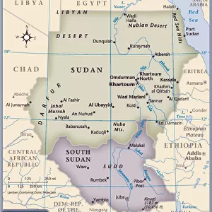
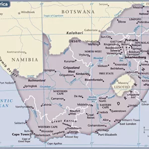
Eritrea country map
2011 edition
Unleash your creativity and transform your space into a visual masterpiece!
Media ID 14432081
Canvas Tote Bag
Our tote bags are made from soft, durable, poly-poplin fabric and include a one inch (2.5cm) black strap for easy carrying on your shoulder. All seams are double-stitched for added durability. Each tote bag is machine-washable in cold water and is printed on both sides using the same image. Approximate size of bag is 50x33cm (20"x13")
Our tote bags are made from soft durable fabric and include a strap for easy carrying
Estimated Product Size is 50cm x 32.7cm (19.7" x 12.9")
These are individually made so all sizes are approximate
FEATURES IN THESE COLLECTIONS
> Fine Art Storehouse
> Map
> Reference Maps
> Africa
> Eritrea
> Related Images
> Maps and Charts
> Related Images
EDITORS COMMENTS
This print showcases the intricate details of the Eritrea country map from the 2011 edition. With its vibrant colors and precise cartographic lines, this artwork captures the essence of Eritrea's diverse landscapes and rich cultural heritage. The map itself is a testament to meticulous craftsmanship, displaying every nook and cranny of this East African nation. From the rugged mountains that stretch across its western border to the pristine coastline along the Red Sea, each geographical feature is beautifully depicted on this print. Beyond its aesthetic appeal, this artwork serves as a gateway to exploration and discovery. It invites viewers to embark on a virtual journey through Eritrea's bustling cities, ancient ruins, and lush national parks. Whether you are an avid traveler or simply curious about different cultures, this print offers a window into one of Africa's hidden gems. With Fine Art Storehouse's commitment to quality prints, you can be assured that every detail in this image is rendered with utmost precision. This particular edition emphasizes clarity and accuracy while maintaining an artistic touch that makes it suitable for display in any setting.
MADE IN THE UK
Safe Shipping with 30 Day Money Back Guarantee
FREE PERSONALISATION*
We are proud to offer a range of customisation features including Personalised Captions, Color Filters and Picture Zoom Tools
SECURE PAYMENTS
We happily accept a wide range of payment options so you can pay for the things you need in the way that is most convenient for you
* Options may vary by product and licensing agreement. Zoomed Pictures can be adjusted in the Basket.