Premium Framed Print > Africa > Eritrea > Maps
Premium Framed Print : Eritrea country map


Please select a smaller print size for this image
![]()
Framed Photos from Fine Art Storehouse
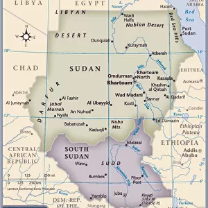
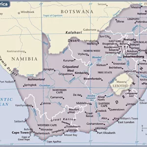
Eritrea country map
2011 edition
Unleash your creativity and transform your space into a visual masterpiece!
Media ID 14432081
14"x12" (38x32cm) Modern Frame
FSC real wood frame with double mounted 24x20 print. Double mounted with white conservation mountboard. Frame moulding comprises stained composite natural wood veneers (Finger Jointed Pine) 39mm wide by 21mm thick. Archival quality Fujifilm CA photo paper mounted onto 1mm card. Overall outside dimensions are 31x27 inches (787x685mm). Rear features Framing tape to cover staples, 50mm Hanger plate, cork bumpers. Glazed with durable thick 2mm Acrylic to provide a virtually unbreakable glass-like finish. Acrylic Glass is far safer, more flexible and much lighter than typical mineral glass. Moreover, its higher translucency makes it a perfect carrier for photo prints. Acrylic allows a little more light to penetrate the surface than conventional glass and absorbs UV rays so that the image and the picture quality doesn't suffer under direct sunlight even after many years. Easily cleaned with a damp cloth. Please note that, to prevent the paper falling through the mount window and to prevent cropping of the original artwork, the visible print may be slightly smaller to allow the paper to be securely attached to the mount without any white edging showing and to match the aspect ratio of the original artwork.
FSC Real Wood Frame and Double Mounted with White Conservation Mountboard - Professionally Made and Ready to Hang
Estimated Product Size is 37.6cm x 32.5cm (14.8" x 12.8")
These are individually made so all sizes are approximate
Artwork printed orientated as per the preview above, with landscape (horizontal) orientation to match the source image.
FEATURES IN THESE COLLECTIONS
> Fine Art Storehouse
> Map
> Reference Maps
> Africa
> Eritrea
> Related Images
> Maps and Charts
> Related Images
EDITORS COMMENTS
This print showcases the intricate details of the Eritrea country map from the 2011 edition. With its vibrant colors and precise cartographic lines, this artwork captures the essence of Eritrea's diverse landscapes and rich cultural heritage. The map itself is a testament to meticulous craftsmanship, displaying every nook and cranny of this East African nation. From the rugged mountains that stretch across its western border to the pristine coastline along the Red Sea, each geographical feature is beautifully depicted on this print. Beyond its aesthetic appeal, this artwork serves as a gateway to exploration and discovery. It invites viewers to embark on a virtual journey through Eritrea's bustling cities, ancient ruins, and lush national parks. Whether you are an avid traveler or simply curious about different cultures, this print offers a window into one of Africa's hidden gems. With Fine Art Storehouse's commitment to quality prints, you can be assured that every detail in this image is rendered with utmost precision. This particular edition emphasizes clarity and accuracy while maintaining an artistic touch that makes it suitable for display in any setting.
MADE IN THE UK
Safe Shipping with 30 Day Money Back Guarantee
FREE PERSONALISATION*
We are proud to offer a range of customisation features including Personalised Captions, Color Filters and Picture Zoom Tools
SECURE PAYMENTS
We happily accept a wide range of payment options so you can pay for the things you need in the way that is most convenient for you
* Options may vary by product and licensing agreement. Zoomed Pictures can be adjusted in the Basket.