Tote Bag > Europe > Italy > Tuscany > Florence
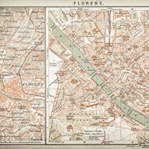
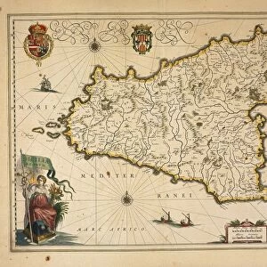
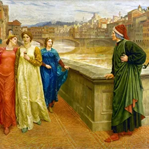
Tote Bag : City map of Florence, Italy, lithograph, published in 1897


![]()
Home Decor from Fine Art Storehouse
City map of Florence, Italy, lithograph, published in 1897
City map of Florence - capital city of the Italian region of Tuscany. Lithograph, published in 1897
Unleash your creativity and transform your space into a visual masterpiece!
Media ID 15133674
© This content is subject to copyright
Arno River City Map European Culture Florence Italian Culture Past Plan Tuscany Multi Colored
Canvas Tote Bag
Our tote bags are made from soft, durable, poly-poplin fabric and include a one inch (2.5cm) black strap for easy carrying on your shoulder. All seams are double-stitched for added durability. Each tote bag is machine-washable in cold water and is printed on both sides using the same image. Approximate size of bag is 50x33cm (20"x13")
Our tote bags are made from soft durable fabric and include a strap for easy carrying
Estimated Product Size is 50cm x 32.7cm (19.7" x 12.9")
These are individually made so all sizes are approximate
FEATURES IN THESE COLLECTIONS
> Fine Art Storehouse
> Map
> Historical Maps
> Fine Art Storehouse
> Map
> Italian Maps
> Arts
> Landscape paintings
> Landscape art
> Landscape paintings
> Arts
> Landscape paintings
> Waterfall and river artworks
> Landscape paintings
> Arts
> Landscape paintings
> Waterfall and river artworks
> River artworks
> Europe
> Italy
> Related Images
> Europe
> Italy
> Tuscany
> Florence
> Europe
> Italy
> Tuscany
> Related Images
EDITORS COMMENTS
This lithograph, published in 1897, showcases a city map of Florence - the enchanting capital city of Tuscany, Italy. Steeped in rich Italian culture and history, this print offers a glimpse into the past as it beautifully captures the essence of this European gem. The intricate details within the map highlight Florence's unique landscape. The Arno River gracefully meanders through the heart of the city, dividing it into distinct sections. From its source to its mouth, this lifeline has played an integral role in shaping Florence's identity over centuries. Rendered with vibrant colors and meticulous precision, this horizontal lithograph is a testament to the artistry and craftsmanship prevalent during the 19th century. Its multi-colored palette adds depth and character to every street corner and architectural landmark depicted on this historical document. As you explore each intricately engraved street and alleyway on this map, you can almost feel yourself being transported back in time - wandering through narrow cobblestone streets lined with Renaissance palaces or strolling along picturesque bridges that span across ancient waterways. Whether you are an avid historian or simply captivated by European culture, this exquisite lithograph serves as both a visual delight and a valuable piece of art that encapsulates Florence's charm from long ago.
MADE IN THE UK
Safe Shipping with 30 Day Money Back Guarantee
FREE PERSONALISATION*
We are proud to offer a range of customisation features including Personalised Captions, Color Filters and Picture Zoom Tools
SECURE PAYMENTS
We happily accept a wide range of payment options so you can pay for the things you need in the way that is most convenient for you
* Options may vary by product and licensing agreement. Zoomed Pictures can be adjusted in the Basket.