Tote Bag > Europe > United Kingdom > Northern Ireland > County Down > Newcastle
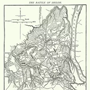
Tote Bag : Map of the area between Newcastle and Transvaal South Africa


![]()
Home Decor from Fine Art Storehouse
Map of the area between Newcastle and Transvaal South Africa
Vintage illustration Map of the area between Newcastle and Transvaal South Africa, during the First Boar War, 19th Century
Unleash your creativity and transform your space into a visual masterpiece!
duncan1890
Media ID 20327741
© of Duncan P Walker
Canvas Tote Bag
Our tote bags are made from soft, durable, poly-poplin fabric and include a one inch (2.5cm) black strap for easy carrying on your shoulder. All seams are double-stitched for added durability. Each tote bag is machine-washable in cold water and is printed on both sides using the same image. Approximate size of bag is 50x33cm (20"x13")
Our tote bags are made from soft durable fabric and include a strap for easy carrying
Estimated Product Size is 32.7cm x 50cm (12.9" x 19.7")
These are individually made so all sizes are approximate
FEATURES IN THESE COLLECTIONS
> Fine Art Storehouse
> History
> Battles & Wars
> Historcal Battle Maps and Plans
> Africa
> Related Images
> Africa
> South Africa
> Maps
> Africa
> South Africa
> Related Images
> Europe
> United Kingdom
> Northern Ireland
> County Down
> Newcastle
> Maps and Charts
> Related Images
EDITORS COMMENTS
This vintage illustration map takes us back to the 19th century, specifically during the First Boer War. The intricate details and historical significance of this print transport us to the area between Newcastle and Transvaal South Africa, offering a glimpse into a tumultuous period in history. As we gaze upon this piece, we are immediately struck by its rich colors and meticulous craftsmanship. Every line and contour on the map tells a story of conflict, exploration, and territorial disputes that defined this era. It serves as a visual time capsule, allowing us to understand how borders were drawn and contested during this pivotal moment in South African history. The Map of the area between Newcastle and Transvaal South Africa offers more than just geographical information; it provides insight into the political landscape of that time. It reminds us of the struggles faced by both sides during the First Boer War - British forces seeking control over valuable resources against determined Boer resistance fighting for their independence. Duncan1890's expertly preserved print captures not only an important chapter in history but also showcases his passion for preserving these significant moments through art. This artwork is not just an image; it is a gateway to understanding our past – reminding us that even amidst conflict, there is beauty in historical documentation.
MADE IN THE UK
Safe Shipping with 30 Day Money Back Guarantee
FREE PERSONALISATION*
We are proud to offer a range of customisation features including Personalised Captions, Color Filters and Picture Zoom Tools
SECURE PAYMENTS
We happily accept a wide range of payment options so you can pay for the things you need in the way that is most convenient for you
* Options may vary by product and licensing agreement. Zoomed Pictures can be adjusted in the Basket.