Framed Print > Europe > United Kingdom > Northern Ireland > County Down > Newcastle
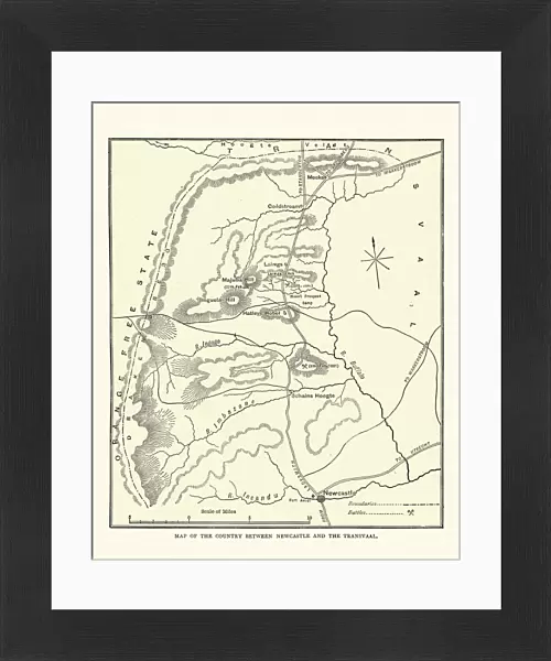
Framed Print : Map of the area between Newcastle and Transvaal South Africa


![]()
Framed Photos from Fine Art Storehouse
Map of the area between Newcastle and Transvaal South Africa
Vintage illustration Map of the area between Newcastle and Transvaal South Africa, during the First Boar War, 19th Century
Unleash your creativity and transform your space into a visual masterpiece!
duncan1890
Media ID 20327741
© of Duncan P Walker
14"x12" (38x32cm) Modern Frame
Step back in time with our exquisite Framed Print of "Map of the Area between Newcastle and Transvaal, South Africa" by duncan1890 from our Media Storehouse Fine Art collection. This vintage illustration, depicting the region during the First Boer War in the 19th century, is a captivating addition to any home or office. Each Framed Print is meticulously crafted with attention to detail, ensuring a high-quality presentation of this historical piece. Transport yourself to a bygone era with this unique and intriguing work of art.
Wood effect frame, card mounted, 10x8 archival quality photo print. Overall outside dimensions 14x12 inches (38x32cm). Environmentally and ozone friendly, 40mm wide x 15mm Polycore® moulding has the look of real wood, is durable and light and easy to hang. Biodegradable and made with non-chlorinated gases (no toxic fumes) it is efficient; producing 100 tons of polystyrene can save 300 tons of trees! Prints are glazed with lightweight, shatterproof, optical clarity acrylic (providing the same general protection from the environment as glass). The back is stapled hardboard with a sawtooth hanger attached. Note: To minimise original artwork cropping, for optimum layout, and to ensure print is secure, the visible print may be marginally smaller
Contemporary Framed and Mounted Prints - Professionally Made and Ready to Hang
Estimated Image Size (if not cropped) is 19.5cm x 24.4cm (7.7" x 9.6")
Estimated Product Size is 32.5cm x 37.6cm (12.8" x 14.8")
These are individually made so all sizes are approximate
Artwork printed orientated as per the preview above, with portrait (vertical) orientation to match the source image.
FEATURES IN THESE COLLECTIONS
> Fine Art Storehouse
> History
> Battles & Wars
> Historcal Battle Maps and Plans
> Africa
> Related Images
> Africa
> South Africa
> Maps
> Africa
> South Africa
> Related Images
> Europe
> United Kingdom
> Northern Ireland
> County Down
> Newcastle
> Maps and Charts
> Related Images
EDITORS COMMENTS
This vintage illustration map takes us back to the 19th century, specifically during the First Boer War. The intricate details and historical significance of this print transport us to the area between Newcastle and Transvaal South Africa, offering a glimpse into a tumultuous period in history. As we gaze upon this piece, we are immediately struck by its rich colors and meticulous craftsmanship. Every line and contour on the map tells a story of conflict, exploration, and territorial disputes that defined this era. It serves as a visual time capsule, allowing us to understand how borders were drawn and contested during this pivotal moment in South African history. The Map of the area between Newcastle and Transvaal South Africa offers more than just geographical information; it provides insight into the political landscape of that time. It reminds us of the struggles faced by both sides during the First Boer War - British forces seeking control over valuable resources against determined Boer resistance fighting for their independence. Duncan1890's expertly preserved print captures not only an important chapter in history but also showcases his passion for preserving these significant moments through art. This artwork is not just an image; it is a gateway to understanding our past – reminding us that even amidst conflict, there is beauty in historical documentation.
MADE IN THE UK
Safe Shipping with 30 Day Money Back Guarantee
FREE PERSONALISATION*
We are proud to offer a range of customisation features including Personalised Captions, Color Filters and Picture Zoom Tools
SECURE PAYMENTS
We happily accept a wide range of payment options so you can pay for the things you need in the way that is most convenient for you
* Options may vary by product and licensing agreement. Zoomed Pictures can be adjusted in the Basket.