Tote Bag > Europe > Bosnia and Herzegovina > Maps
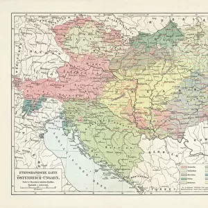
Tote Bag : Map of the Kingdom of Hungary, 1742 (hand coloured engraving)
")
")

![]()
Home Decor from Fine Art Finder
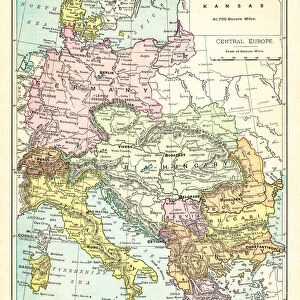
Map of the Kingdom of Hungary, 1742 (hand coloured engraving)
XCF306032 Map of the Kingdom of Hungary, 1742 (hand coloured engraving) by Mortier, Pierre (Pieter) (1661-1711) (after); 48x57 cm; Private Collection; French, out of copyright
Media ID 18254907
© Private Collection / Bridgeman Images
Balkans Bosnia Bulgaria Cartouche Countries Croatia Eastern Europe Eastern European Magyar Mapping Moldavia Romania Serbia Slovakia States Transylvania Transilvania
Canvas Tote Bag
Our tote bags are made from soft, durable, poly-poplin fabric and include a one inch (2.5cm) black strap for easy carrying on your shoulder. All seams are double-stitched for added durability. Each tote bag is machine-washable in cold water and is printed on both sides using the same image. Approximate size of bag is 50x33cm (20"x13")
Our tote bags are made from soft durable fabric and include a strap for easy carrying
Estimated Product Size is 50cm x 32.7cm (19.7" x 12.9")
These are individually made so all sizes are approximate
FEATURES IN THESE COLLECTIONS
> Europe
> Bosnia and Herzegovina
> Maps
> Europe
> Bulgaria
> Related Images
> Europe
> Croatia
> Related Images
EDITORS COMMENTS
This hand-coloured engraving, titled "Map of the Kingdom of Hungary, 1742" takes us on a journey back in time to explore the intricate details of Eastern Europe's historical landscape. Measuring 48x57 cm, this exquisite piece is part of a private collection and showcases the exceptional craftsmanship of Pierre Mortier (1661-1711), who created it based on an earlier work. The map offers a fascinating glimpse into the Hungarian Empire during its peak in the mid-18th century. With its vibrant colours and meticulous cartography, it reveals not only the boundaries and states within Hungary but also neighboring regions such as Transylvania, Moldavia, Bosnia, Croatia, Romania, Slovakia, Bulgaria, Serbia and more. One cannot help but be drawn to the beautifully adorned cartouche that adorns this print. Its ornate design adds an air of elegance to an already impressive artwork. This map serves as both a navigational tool for explorers and historians alike while also being a stunning decorative piece that captures the essence of Eastern European history. As we gaze upon this remarkable creation from centuries past – now made available through www. bridgemanimages. com – we are reminded of how maps have always been essential in understanding our world's ever-changing landscapes. Whether used for practical purposes or admired purely for their artistic value like this one here; they continue to connect us with our rich cultural heritage.
MADE IN THE UK
Safe Shipping with 30 Day Money Back Guarantee
FREE PERSONALISATION*
We are proud to offer a range of customisation features including Personalised Captions, Color Filters and Picture Zoom Tools
SECURE PAYMENTS
We happily accept a wide range of payment options so you can pay for the things you need in the way that is most convenient for you
* Options may vary by product and licensing agreement. Zoomed Pictures can be adjusted in the Basket.