Tote Bag > Fine Art Finder > Artists > Frederick de Wit
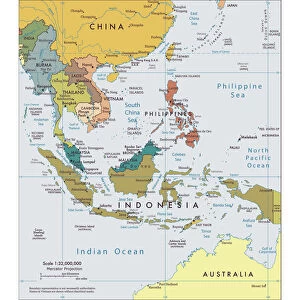
Tote Bag : Map of India and the East Indies (hand-coloured engraving)
")
")

Please select a smaller print size for this image
![]()
Home Decor from Fine Art Finder
Map of India and the East Indies (hand-coloured engraving)
XCF307353 Map of India and the East Indies (hand-coloured engraving) by Wit, Frederick de (1630-1706); Private Collection; Dutch, out of copyright
Media ID 12841988
© www.bridgemanimages.com
Bali Borneo Cambodia Cartouche Geographical Indian Ocean Indonesia Islands Java Mapping New Guinea Siam South East Asia Sumatra Thailand
Canvas Tote Bag
Our tote bags are made from soft, durable, poly-poplin fabric and include a one inch (2.5cm) black strap for easy carrying on your shoulder. All seams are double-stitched for added durability. Each tote bag is machine-washable in cold water and is printed on both sides using the same image. Approximate size of bag is 50x33cm (20"x13")
Our tote bags are made from soft durable fabric and include a strap for easy carrying
Estimated Product Size is 50cm x 32.7cm (19.7" x 12.9")
These are individually made so all sizes are approximate
EDITORS COMMENTS
This hand-coloured engraving, titled "Map of India and the East Indies" takes us on a visual journey through the diverse lands of South East Asia. Created by Frederick de Wit in the 17th century, this exquisite piece is a testament to his mastery in cartography. The map showcases an array of enchanting destinations, from the vast Indian subcontinent to the scattered islands dotting the Indian Ocean. With meticulous detail, it highlights significant regions such as Australia, New Guinea, Sumatra, Borneo, Cambodia, Java, Siam (now Thailand), and Indonesia. As our eyes wander across this intricate artwork, we are drawn towards its central focal point - a beautifully adorned cartouche that adds an air of elegance to the composition. This decorative element serves as a reminder of how artistry intertwines with geography. Through this print's vibrant colors and precise lines, we gain insight into historical trade routes and colonial influences that shaped these lands centuries ago. It invites us to reflect upon their rich cultural heritage and geographical significance. Whether you are an avid collector or simply fascinated by maps and exploration, this remarkable print offers both aesthetic pleasure and educational value. Its depiction of Asian landscapes provides a gateway into understanding past civilizations while igniting curiosity about our world's interconnectedness. Unveiling hidden treasures within its details – Bali's lush beauty or Java's bustling cities – this map beckons adventurers to embark on their own journeys through time and space.
MADE IN THE UK
Safe Shipping with 30 Day Money Back Guarantee
FREE PERSONALISATION*
We are proud to offer a range of customisation features including Personalised Captions, Color Filters and Picture Zoom Tools
SECURE PAYMENTS
We happily accept a wide range of payment options so you can pay for the things you need in the way that is most convenient for you
* Options may vary by product and licensing agreement. Zoomed Pictures can be adjusted in the Basket.