Home > Europe > United Kingdom > Wales > Caernarfonshire
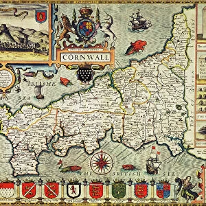
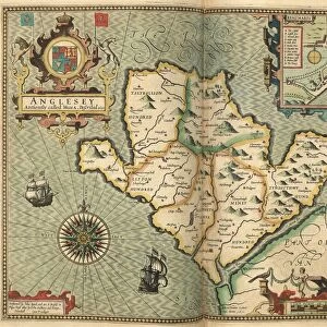
John Speed's map of Caernarfonshire, 1611

![]()
Wall Art and Photo Gifts from Sheffield City Archives
John Speed's map of Caernarfonshire, 1611
Also known as Caernarvonshire and Carnarvonshire.
Image from Theatre of the Empire of Great Britaine presenting an exact geography of the Kingdomes of Ireland, Scotland, Ireland, and the Iles adioyning with The Shires, Hundreds, Cities and Shire Towns, within ye Kingdome of England, divided and described by John Speed (original at Sheffield Libraries: 914.2 SQ).
Note this image is of a genuine 400-year-old map from a tightly bound volume. It shows some wear and tear as well as the binding in the middle of the image
Sheffield City Archives and Local Studies Library has an unrivalled collection of images of Sheffield, England
Media ID 26401468
© Sheffield City Council - All Rights Reserved
FEATURES IN THESE COLLECTIONS
> Arts
> Artists
> S
> John Speed
> Europe
> Republic of Ireland
> Maps
> Europe
> United Kingdom
> England
> Maps
> Europe
> United Kingdom
> England
> Sheffield
> Europe
> United Kingdom
> England
> Wells
> Europe
> United Kingdom
> Scotland
> Maps
> Europe
> United Kingdom
> Wales
> Caernarfonshire
> Europe
> United Kingdom
> Wales
> Maps
> Sheffield City Archives
> Maps and Plans
> John Speed's County Maps, 1611
> Sheffield City Archives
> Maps and Plans
> Maps of Wales
EDITORS COMMENTS
This print showcases John Speed's map of Caernarfonshire, dating back to 1611. Also referred to as Caernarvonshire and Carnarvonshire, this historical piece is a part of the renowned Theatre of the Empire of Great Britaine collection. The image provides an exact geography of various kingdoms within the British Isles, including Ireland, Scotland, and England. Preserved in Sheffield Libraries' archives (914.2 SQ), this genuine 400-year-old map offers a glimpse into the past with its visible signs of wear and tear. The tightly bound volume it originates from adds an authentic touch to its overall appearance. As you explore this remarkable artifact, you may notice some imperfections caused by time's passage—proof that it has stood witness to centuries gone by. Notably positioned in the middle is evidence of binding marks that have become a part of its story. It is important to note that this image should not be associated with any commercial use or company endorsement; rather, it serves as a testament to our rich history and cultural heritage. Delve into the intricate details captured on this ancient map and allow yourself to be transported back in time—a visual representation steeped in significance for both historians and enthusiasts alike.
MADE IN THE UK
Safe Shipping with 30 Day Money Back Guarantee
FREE PERSONALISATION*
We are proud to offer a range of customisation features including Personalised Captions, Color Filters and Picture Zoom Tools
SECURE PAYMENTS
We happily accept a wide range of payment options so you can pay for the things you need in the way that is most convenient for you
* Options may vary by product and licensing agreement. Zoomed Pictures can be adjusted in the Basket.