Home > Arts > Artists > S > Petrus Schenk
Earths celestial circles, 1708 artwork

![]()
Wall Art and Photo Gifts from Science Photo Library
Earths celestial circles, 1708 artwork
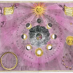
The Earth and its celestial circles. This artwork is from the 1708 edition of the star atlas Harmonica Macrocosmica, by the Dutch-German mathematician and cosmographer Andreas Cellarius (1596-1665). The two major planes shown here are the horizon (pink) and the zodiac (illustrated with zodiacal symbols). The globe is centred on the north coast of Australia (mapped in 1644). Cherubs and muses adorn the artworks border. Harmonica Macrocosmica was first published in 1660. There were originally 30 colour plates with Latin text. This edition was published in Amsterdam by Petrus Schenk (1660-1711) and Gerard Valk (1652-1726)
Science Photo Library features Science and Medical images including photos and illustrations
Media ID 6470573
© ROYAL ASTRONOMICAL SOCIETY/SCIENCE PHOTO LIBRARY
1600s 1660 1700s 1708 17th Century 18th Century Age Of Discovery Andreas Cellarius Arctic Circle Australia Australian Cartography Celestial Diagram Discovery Dutch Engraving Equator German Harmonica Macrocosmica History Of Science Horizon Latin Meridian Renaissance Star Atlas Universe Zodiac Antarctic Circle Map Making Petrus Schenk Tropic Of Cancer Tropic Of Capricorn
FEATURES IN THESE COLLECTIONS
> Arts
> Artists
> C
> Andreas Cellarius
> Arts
> Artists
> S
> Petrus Schenk
> Science
> Space Exploration
> Planets
> Earth
EDITORS COMMENTS
This print showcases the intricate artwork titled "Earths celestial circles, 1708" from the renowned star atlas Harmonica Macrocosmica. Created by the brilliant Dutch-German mathematician and cosmographer Andreas Cellarius in the 17th century, this masterpiece takes us on a journey through space and time. The image highlights two significant planes: the horizon depicted in a delicate shade of pink and the zodiac adorned with its symbolic representations. The globe itself is centered on Australia's north coast, meticulously mapped in 1644. Surrounding this celestial map are cherubs and muses, enhancing its beauty with their ethereal presence. Originally published in 1660, Harmonica Macrocosmica featured thirty color plates accompanied by Latin text. This particular edition was brought to life in Amsterdam by Petrus Schenk and Gerard Valk during the early 18th century. Its historical significance lies not only in its artistic brilliance but also as a testament to humanity's relentless pursuit of knowledge during the Age of Discovery. With elements such as meridians, equators, tropics of Cancer and Capricorn, Arctic Circle, Antarctic Circle, and other celestial circles intricately illustrated within this engraving; it serves as a remarkable representation of our understanding of astronomy at that time. As we gaze upon this extraordinary piece of artistry steeped in history and scientific exploration, we are reminded of how far we have come while appreciating those who paved the way for our modern understanding of our vast universe.
MADE IN THE UK
Safe Shipping with 30 Day Money Back Guarantee
FREE PERSONALISATION*
We are proud to offer a range of customisation features including Personalised Captions, Color Filters and Picture Zoom Tools
SECURE PAYMENTS
We happily accept a wide range of payment options so you can pay for the things you need in the way that is most convenient for you
* Options may vary by product and licensing agreement. Zoomed Pictures can be adjusted in the Basket.