Premium Framed Print > North America > United States of America > New York > New York > Sights > Wall Street
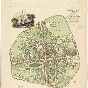
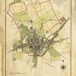
Premium Framed Print : Map of Chichester within the City Walls, 1812


![]()
Framed Photos from West Sussex County Council
Map of Chichester within the City Walls, 1812
Plan of the city of Chichester from an actual survey taken April 1812 by George Loader, Surveyor
Printed Maps Collection
West Sussex Record Office Ref No: PM 154
West Sussex County Council Record Office contains a fascinating history of the county of West Sussex, England
Media ID 5978153
© reserved
Priory Park East Street North Street Pallant South Street Tower Street West Street
17"x15" (43x38cm) Premium Frame
FSC real wood frame with double mounted 10x8 print. Double mounted with white conservation mountboard. Frame moulding comprises stained composite natural wood veneers (Finger Jointed Pine) 39mm wide by 21mm thick. Archival quality Fujifilm CA photo paper mounted onto 1mm card. Overall outside dimensions are 17x15 inches (431x381mm). Rear features Framing tape to cover staples, 50mm Hanger plate, cork bumpers. Glazed with durable thick 2mm Acrylic to provide a virtually unbreakable glass-like finish. Acrylic Glass is far safer, more flexible and much lighter than typical mineral glass. Moreover, its higher translucency makes it a perfect carrier for photo prints. Acrylic allows a little more light to penetrate the surface than conventional glass and absorbs UV rays so that the image and the picture quality doesn't suffer under direct sunlight even after many years. Easily cleaned with a damp cloth. Please note that, to prevent the paper falling through the mount window and to prevent cropping of the original artwork, the visible print may be slightly smaller to allow the paper to be securely attached to the mount without any white edging showing and to match the aspect ratio of the original artwork.
FSC Real Wood Frame and Double Mounted with White Conservation Mountboard - Professionally Made and Ready to Hang
Estimated Image Size (if not cropped) is 17.7cm x 24.4cm (7" x 9.6")
Estimated Product Size is 38.1cm x 43.1cm (15" x 17")
These are individually made so all sizes are approximate
Artwork printed orientated as per the preview above, with portrait (vertical) orientation to match the source image.
FEATURES IN THESE COLLECTIONS
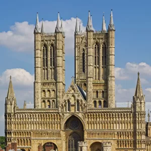
> Architecture
> Towers
> Cathedrals
> Europe
> United Kingdom
> England
> East Sussex
> Related Images
> Europe
> United Kingdom
> England
> Sussex
> Chichester
> Europe
> United Kingdom
> England
> Sussex
> Related Images
> Europe
> United Kingdom
> England
> Sussex
> South Street
> Europe
> United Kingdom
> England
> West Sussex
> Chichester
> Europe
> United Kingdom
> England
> West Sussex
> Related Images
> Historic
> Medieval architecture
> Towers and city walls
> City walls history
> Maps and Charts
> Related Images
> North America
> United States of America
> New York
> New York
> Sights
> Wall Street
> West Sussex County Council
> Urban
> West Sussex County Council
> West Sussex Record Office
> Printed Maps
EDITORS COMMENTS
This print showcases the intricate "Map of Chichester within the City Walls, 1812" meticulously crafted by George Loader, a skilled surveyor of his time. With its rich historical significance, this map offers an invaluable glimpse into the layout and architecture of Chichester during that era. The vibrant colors used to depict Close, South Street, West Street, Priory Park, East Street, North Street, Tower Street are truly striking. Each street is intricately detailed with precision and accuracy. The drawing of the cathedral at the heart of this map serves as a focal point - a testament to its prominence in Chichester's landscape. As we delve deeper into this remarkable piece of cartography from West Sussex Record Office's Printed Maps Collection (Ref No: PM 154), it becomes evident that every element has been thoughtfully included. From landmarks like Pallant House to lesser-known corners tucked away within city walls – no detail has been overlooked. It is important to note that this print is not associated with any commercial use but rather serves as an educational resource for those interested in exploring Chichester's past. Through studying maps such as these, we gain insight into how cities evolve over time and appreciate their unique heritage. In essence, this print encapsulates both artistry and historical documentation seamlessly merged together. It invites us on a journey through time while celebrating the beauty and charm of Chichester within its ancient city walls.
MADE IN THE UK
Safe Shipping with 30 Day Money Back Guarantee
FREE PERSONALISATION*
We are proud to offer a range of customisation features including Personalised Captions, Color Filters and Picture Zoom Tools
SECURE PAYMENTS
We happily accept a wide range of payment options so you can pay for the things you need in the way that is most convenient for you
* Options may vary by product and licensing agreement. Zoomed Pictures can be adjusted in the Basket.

![Chichester St. Peter the Great [Subdeanery] tithe map, 1846-1847](/sq/479/chichester-st-peter-great-subdeanery-tithe-10701869.jpg.webp)


![Royal Engineers bomb disposal team at work, [Mar 1941]](/sq/479/royal-engineers-bomb-disposal-team-work-8359434.jpg.webp)