Jigsaw Puzzle > North America > United States of America > New York > New York > Sights > Wall Street
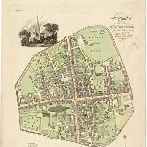
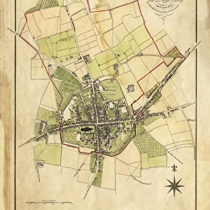
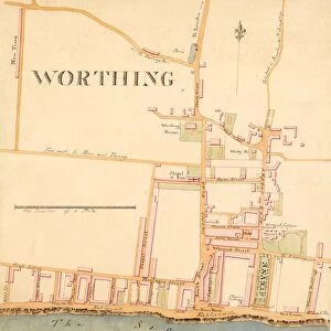
Jigsaw Puzzle : Map of Chichester within the City Walls, 1812


![]()
Jigsaw Puzzles from West Sussex County Council
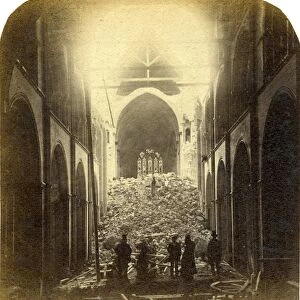
Map of Chichester within the City Walls, 1812
Plan of the city of Chichester from an actual survey taken April 1812 by George Loader, Surveyor
Printed Maps Collection
West Sussex Record Office Ref No: PM 154
West Sussex County Council Record Office contains a fascinating history of the county of West Sussex, England
Media ID 5978153
© reserved
Priory Park East Street North Street Pallant South Street Tower Street West Street
Jigsaw Puzzle (400 Pieces)
Discover the rich history of Chichester with our exquisite jigsaw puzzle from Media Storehouse. This intriguing puzzle features a detailed map of Chichester within the city walls, dating back to 1812. Originally surveyed by George Loader and beautifully preserved in the West Sussex Record Office, this captivating image offers a unique glimpse into the past. Immerse yourself in the puzzle-solving experience and bring the historic city of Chichester to life in your own home. With intricately rendered details, this jigsaw puzzle is perfect for puzzle enthusiasts and history buffs alike. Transport yourself back in time and enjoy the satisfaction of piecing together this fascinating piece of history. The Media Storehouse range of jigsaw puzzles is known for its high-quality, vibrant images and sturdy puzzle pieces, ensuring an enjoyable and rewarding puzzle-solving experience. Unlock the secrets of Chichester and create a beautiful, completed puzzle to display as a conversation starter or a cherished reminder of your historical exploration. Order your Media Storehouse "Map of Chichester within the City Walls, 1812" jigsaw puzzle today and embark on a captivating journey through time.
400 piece puzzles are custom made in the UK and hand-finished on 100% recycled 1.5 mm millboard. There is a level of repetition in jigsaw shapes with each matching piece away from its pair. The completed puzzle measures 31x47cm and is delivered packaged in an attractive presentation box specially designed to fit most letter box slots
Jigsaw Puzzles are an ideal gift for any occasion
Estimated Product Size is 31.5cm x 47.2cm (12.4" x 18.6")
These are individually made so all sizes are approximate
Artwork printed orientated as per the preview above, with landscape (horizontal) or portrait (vertical) orientation to match the source image.
FEATURES IN THESE COLLECTIONS
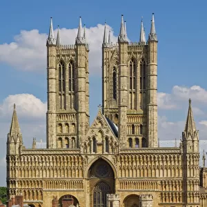
> Architecture
> Towers
> Cathedrals
> Europe
> United Kingdom
> England
> East Sussex
> Related Images
> Europe
> United Kingdom
> England
> Sussex
> Chichester
> Europe
> United Kingdom
> England
> Sussex
> Related Images
> Europe
> United Kingdom
> England
> Sussex
> South Street
> Europe
> United Kingdom
> England
> West Sussex
> Chichester
> Europe
> United Kingdom
> England
> West Sussex
> Related Images
> Historic
> Medieval architecture
> Towers and city walls
> City walls history
> Maps and Charts
> Related Images
> North America
> United States of America
> New York
> New York
> Sights
> Wall Street
> West Sussex County Council
> Urban
> West Sussex County Council
> West Sussex Record Office
> Printed Maps
EDITORS COMMENTS
This print showcases the intricate "Map of Chichester within the City Walls, 1812" meticulously crafted by George Loader, a skilled surveyor of his time. With its rich historical significance, this map offers an invaluable glimpse into the layout and architecture of Chichester during that era. The vibrant colors used to depict Close, South Street, West Street, Priory Park, East Street, North Street, Tower Street are truly striking. Each street is intricately detailed with precision and accuracy. The drawing of the cathedral at the heart of this map serves as a focal point - a testament to its prominence in Chichester's landscape. As we delve deeper into this remarkable piece of cartography from West Sussex Record Office's Printed Maps Collection (Ref No: PM 154), it becomes evident that every element has been thoughtfully included. From landmarks like Pallant House to lesser-known corners tucked away within city walls – no detail has been overlooked. It is important to note that this print is not associated with any commercial use but rather serves as an educational resource for those interested in exploring Chichester's past. Through studying maps such as these, we gain insight into how cities evolve over time and appreciate their unique heritage. In essence, this print encapsulates both artistry and historical documentation seamlessly merged together. It invites us on a journey through time while celebrating the beauty and charm of Chichester within its ancient city walls.
MADE IN THE UK
Safe Shipping with 30 Day Money Back Guarantee
FREE PERSONALISATION*
We are proud to offer a range of customisation features including Personalised Captions, Color Filters and Picture Zoom Tools
SECURE PAYMENTS
We happily accept a wide range of payment options so you can pay for the things you need in the way that is most convenient for you
* Options may vary by product and licensing agreement. Zoomed Pictures can be adjusted in the Basket.

![Chichester St. Peter the Great [Subdeanery] tithe map, 1846-1847](/sq/479/chichester-st-peter-great-subdeanery-tithe-10701869.jpg.webp)


![Royal Engineers bomb disposal team at work, [Mar 1941]](/sq/479/royal-engineers-bomb-disposal-team-work-8359434.jpg.webp)