Premium Framed Print > Europe > United Kingdom > Scotland > Highlands > Alness
Premium Framed Print : Copy made in Cairo in 1456 of the world map prepared by the Arab geographer Muhammad al-Idrisi


![]()
Framed Photos from Universal Images Group (UIG)
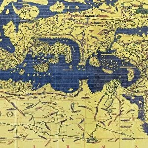
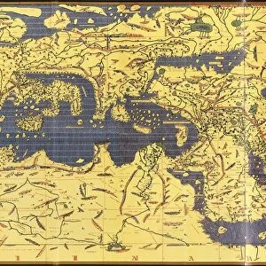
Copy made in Cairo in 1456 of the world map prepared by the Arab geographer Muhammad al-Idrisi
Copy made in Cairo in 1456 of the world map prepared by the Arab geographer Muhammad al-Idrisi (1100-1165) for Roger II (1095-1154) King of Sicily from 1130. In this map, North is at the bottom
Universal Images Group (UIG) manages distribution for many leading specialist agencies worldwide
Media ID 9756859
© Universal History Archive/Universal Images Group
12th Arab Bottom Cairo Century Commerce Copy Geographer King Muhammad North Prepared Roger Sicily Trade Twelfth 1130 1456 Al Idrisi
31"x27" (79x69cm) Premium Frame
FSC real wood frame with double mounted 24x20 print. Double mounted with white conservation mountboard. Frame moulding comprises stained composite natural wood veneers (Finger Jointed Pine) 39mm wide by 21mm thick. Archival quality Fujifilm CA photo paper mounted onto 1mm card. Overall outside dimensions are 31x27 inches (787x685mm). Rear features Framing tape to cover staples, 50mm Hanger plate, cork bumpers. Glazed with durable thick 2mm Acrylic to provide a virtually unbreakable glass-like finish. Acrylic Glass is far safer, more flexible and much lighter than typical mineral glass. Moreover, its higher translucency makes it a perfect carrier for photo prints. Acrylic allows a little more light to penetrate the surface than conventional glass and absorbs UV rays so that the image and the picture quality doesn't suffer under direct sunlight even after many years. Easily cleaned with a damp cloth. Please note that, to prevent the paper falling through the mount window and to prevent cropping of the original artwork, the visible print may be slightly smaller to allow the paper to be securely attached to the mount without any white edging showing and to match the aspect ratio of the original artwork.
FSC Real Wood Frame and Double Mounted with White Conservation Mountboard - Professionally Made and Ready to Hang
Estimated Image Size (if not cropped) is 55cm x 59.9cm (21.7" x 23.6")
Estimated Product Size is 68.5cm x 78.7cm (27" x 31")
These are individually made so all sizes are approximate
Artwork printed orientated as per the preview above, with portrait (vertical) orientation to match the source image.
FEATURES IN THESE COLLECTIONS
> Europe
> Italy
> Sicily
> Related Images
> Europe
> United Kingdom
> Scotland
> Highlands
> Alness
> Maps and Charts
> Related Images
> Maps and Charts
> World
> Universal Images Group (UIG)
> History
EDITORS COMMENTS
This print showcases a remarkable piece of history - a copy made in Cairo in 1456 of the world map prepared by the esteemed Arab geographer Muhammad al-Idrisi for Roger II, the King of Sicily during the 12th century. In this intricate map, an intriguing twist awaits as North is depicted at the bottom rather than its conventional position at the top. The significance of this map lies not only in its stunning cartography but also in its representation of a pivotal era marked by exploration and trade. It serves as a testament to the flourishing commerce and cultural exchange that characterized this period between different regions across the globe. Muhammad al-Idrisi's meticulous craftsmanship and geographical knowledge are evident through his detailed depiction of various lands, seas, and continents. This masterpiece provides invaluable insights into how people perceived and understood our world centuries ago. As we delve into this image, we are transported back to Cairo in 1456 when skilled artisans worked diligently to reproduce al-Idrisi's original creation for future generations to admire. The delicate lines and vibrant colors bring life to each corner of this ancient map, inviting us on an imaginary journey through time. Let us marvel at this extraordinary artifact that bridges cultures, connects historical figures like Roger II with Muhammad al-Idrisi, and reminds us of humanity's ceaseless quest for knowledge about our planet.
MADE IN THE UK
Safe Shipping with 30 Day Money Back Guarantee
FREE PERSONALISATION*
We are proud to offer a range of customisation features including Personalised Captions, Color Filters and Picture Zoom Tools
SECURE PAYMENTS
We happily accept a wide range of payment options so you can pay for the things you need in the way that is most convenient for you
* Options may vary by product and licensing agreement. Zoomed Pictures can be adjusted in the Basket.