Premium Framed Print > Arts > Artists > O > Abraham Ortelius
Premium Framed Print : Orteliuss map of Holland, 1570


![]()
Framed Photos from Science Photo Library
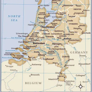
Orteliuss map of Holland, 1570
Orteliuss map of Holland. This map is from the 1570 first edition of Theatrum orbis terrarum ( Theatre of the World ). Drawn by the Flemish mapmaker Abraham Ortelius (1527-1598), and published by Gilles Coppens de Diest in Antwerp, this collection of 53 maps is considered to be the first true modern atlas
Science Photo Library features Science and Medical images including photos and illustrations
Media ID 6298705
© LIBRARY OF CONGRESS, GEOGRAPHY AND MAP DIVISION/SCIENCE PHOTO LIBRARY
1500s 1570 1570 Edition 16th Century Abraham Ortelius Age Of Discovery Antwerp Edition Cartographic Cartography Country Dutch First Edition First Modern Atlas Flemish Gilles Coppens De Diest Holland Latin Latin Edition Nation Netherlands Orteliuss Text Theatre Of The World Theatrum Orbis Terrarum Writing
17"x15" (43x38cm) Premium Frame
FSC real wood frame with double mounted 10x8 print. Double mounted with white conservation mountboard. Frame moulding comprises stained composite natural wood veneers (Finger Jointed Pine) 39mm wide by 21mm thick. Archival quality Fujifilm CA photo paper mounted onto 1mm card. Overall outside dimensions are 17x15 inches (431x381mm). Rear features Framing tape to cover staples, 50mm Hanger plate, cork bumpers. Glazed with durable thick 2mm Acrylic to provide a virtually unbreakable glass-like finish. Acrylic Glass is far safer, more flexible and much lighter than typical mineral glass. Moreover, its higher translucency makes it a perfect carrier for photo prints. Acrylic allows a little more light to penetrate the surface than conventional glass and absorbs UV rays so that the image and the picture quality doesn't suffer under direct sunlight even after many years. Easily cleaned with a damp cloth. Please note that, to prevent the paper falling through the mount window and to prevent cropping of the original artwork, the visible print may be slightly smaller to allow the paper to be securely attached to the mount without any white edging showing and to match the aspect ratio of the original artwork.
FSC Real Wood Frame and Double Mounted with White Conservation Mountboard - Professionally Made and Ready to Hang
Estimated Image Size (if not cropped) is 24.4cm x 17.9cm (9.6" x 7")
Estimated Product Size is 43.1cm x 38.1cm (17" x 15")
These are individually made so all sizes are approximate
Artwork printed orientated as per the preview above, with landscape (horizontal) orientation to match the source image.
FEATURES IN THESE COLLECTIONS
> Arts
> Artists
> O
> Abraham Ortelius
> Europe
> Netherlands
> Maps
> Europe
> Netherlands
> Posters
> Europe
> Netherlands
> Related Images
> Maps and Charts
> Abraham Ortelius
> Maps and Charts
> Early Maps
> Maps and Charts
> Netherlands
> Maps and Charts
> Related Images
> Maps and Charts
> World
EDITORS COMMENTS
This print showcases Orteliuss map of Holland, a remarkable piece of cartographic art from the 16th century. Created by the renowned Flemish mapmaker Abraham Ortelius and published in Antwerp by Gilles Coppens de Diest, this map is part of the esteemed Theatrum orbis terrarum (Theatre of the World) collection. Considered to be the first true modern atlas, this Latin edition contains 53 meticulously drawn maps that provide a comprehensive geographical representation. Intricate details adorn this historical illustration, offering a glimpse into Europe's Age of Discovery. The Dutch nation is beautifully depicted with precision and accuracy, showcasing its prominent position on the continent during that era. Each stroke tells a story as it traces rivers, outlines coastlines, and highlights major cities within Holland. Orteliuss map not only serves as an invaluable tool for understanding European geography but also stands as a testament to artistic excellence. Its intricate design and attention to detail make it an impressive work of art in its own right. As we gaze upon this stunning print, we are transported back in time to witness an important milestone in cartography—a moment when exploration and knowledge converged to create something truly extraordinary: the first modern atlas known as Theatre of the World.
MADE IN THE UK
Safe Shipping with 30 Day Money Back Guarantee
FREE PERSONALISATION*
We are proud to offer a range of customisation features including Personalised Captions, Color Filters and Picture Zoom Tools
SECURE PAYMENTS
We happily accept a wide range of payment options so you can pay for the things you need in the way that is most convenient for you
* Options may vary by product and licensing agreement. Zoomed Pictures can be adjusted in the Basket.